


Over the course of several decades, the scientific community has relied on satellite data to evaluate the well-being and luxuriance of Earth’s vegetation. This wealth of data has been instrumental in shaping our comprehension and influencing decision-making processes on critical issues, ranging from sustainable crop production to addressing the multifaceted challenges posed by climate change.
The role of terrestrial plants in mitigating the impacts of climate change is particularly noteworthy. Annually, plants on land absorb a significant one-third of anthropogenic carbon emissions, making a substantial contribution to the global effort to counteract the emerging consequences of climate change. Earth’s vegetation, in addition to its role in carbon sequestration, stands as the primary source of sustenance for both the diverse wildlife population and the human population, which currently numbers around eight billion.
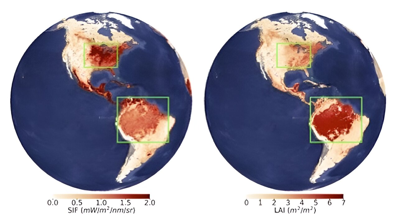
Recently, scientists have encountered a perplexing anomaly in satellite-derived measurements of vegetation greenness—a parameter commonly used as a proxy for leaf abundance and overall vegetation productivity. This enigma pertains to the observation that measures of vegetation greenness over the US Corn Belt surpass those over the Amazon rainforest, despite the latter having a substantially larger leaf area.
Intriguingly, the Amazonian forests boast approximately twice as many leaves per unit area compared to the US Corn Belt, with measurements of 5.7±0.6 m2/m2 versus 2.6±0.3 m2/m2, respectively. Contrary to intuitive expectations, the greenness measure of the Amazon rainforest does not align proportionally higher than that of the Corn Belt. This anomaly poses a puzzle for scientists, challenging conventional assumptions about how vegetation greenness correlates with leaf area, and underscores the intricacies involved in interpreting satellite-derived data on Earth’s ecosystems. Unraveling this mystery holds the potential to enhance our understanding of the complex dynamics governing terrestrial vegetation and refine our tools for assessing global ecosystems from space.
In a groundbreaking revelation published in Nature Ecology & Evolution, researchers have unveiled a profound insight that resolves the perplexing paradox observed in satellite-derived vegetation greenness measurements. This discovery challenges our existing perspective on Earth’s ecosystems, hinting at the possibility that our understanding may have been skewed by a distorted lens.
A collaborative effort involving researchers from 12 institutions spanning five different countries, including the University of Wisconsin–Madison, NASA’s Ames Research Center, and the Pacific Northwest National Laboratory (PNNL), conducted an extensive study to decipher the underlying cause of this enigmatic pattern. Their findings bring to light the role of shadows, particularly those cast by intricate canopy structures, in introducing significant negative biases into satellite-derived greenness measures. This revelation prompts a reevaluation of our comprehension of global vegetation dynamics and the factors influencing its changes.
Yelu Zeng, a lead author of the study and a professor at China Agricultural University (formerly a research scientist at the University of Wisconsin–Madison during the study), articulated the hypothesis driving their investigation. The team postulated that shadows cast by complex canopies, such as those found in the Amazon rainforests, could contribute to the observed paradoxical phenomenon. The Amazon’s intricate canopy, in contrast to the more uniform canopies of the US Corn Belt, offered a natural experiment to test this hypothesis due to its varying canopy-structure complexity, leading to distinct shadowing conditions.
To empirically demonstrate the impact of canopy-cast shadows on satellite vegetation-greenness measures, the researchers conducted an in-depth analysis of how light interacts with the vegetation canopy. Employing state-of-the-art radiative transfer modeling, the team incorporated data from multiple NASA missions and programs, including multi-angular, hyperspectral, and lidar data. Emphasis was placed on understanding the intricate geometry between the satellite, the sun, and Earth’s vegetation.
This study marks a pivotal moment in refining our observational tools for monitoring vegetation health and dynamics, emphasizing the critical role that shadows play in distorting our perception of Earth’s greenery. By elucidating the influence of canopy shadows, this research contributes not only to the advancement of remote sensing technologies but also to a more accurate and nuanced understanding of our planet’s ecosystems.
Taejin Park, a research scientist at NASA Ames Research Center / Bay Area Environmental Research Institute (BAERI) and one of the co-first authors of the study, illustrated the impact of sunlight direction on vegetation observation. When standing with the sun behind, leaves appear brighter with fewer shadows. In contrast, when the sun is in front, more shadows are cast, leading to darker leaves. The complexity of a canopy structure intensifies the presence and significance of these shadows, emphasizing their crucial role in shaping the perceived characteristics of vegetation in satellite-derived measurements.

The repercussions of the shadow effect transcend mere technical nuances in satellite data interpretation, delving into profound implications for global vegetation studies. The research team, as detailed in their paper, explores the broader implications of this phenomenon on our understanding of vegetation dynamics on a global scale. One illustrative example they provide pertains to the conversion of land from forest to crops, revealing an unexpected surge in vegetation greenness in satellite data. This paradoxical increase persists despite the evident loss of green leaves when forests are supplanted by crop fields.
Dalei Hao, a co-first author of the study and a research scientist at the Pacific Northwest National Laboratory (PNNL), underscores the significance of these findings, particularly in the context of deforestation in the Amazon rainforest driven by cropland expansion. The observed increase in vegetation greenness post-conversion challenges conventional expectations and adds a layer of complexity to our comprehension of the environmental impact of land-use changes.
The study emphasizes the imperative need to factor in the shadow effect when employing various satellite-based measures of greenness, including solar-induced chlorophyll fluorescence (SIF). SIF serves as an innovative and widely utilized metric for gauging the photosynthetic activity of plants, a parameter of immense value in global vegetation studies. With numerous Earth-observing satellites actively collecting SIF data, acknowledging and mitigating the shadow effect becomes crucial for ensuring the accuracy and reliability of assessments related to vegetation health and dynamics on a planetary scale. This research, therefore, not only advances our grasp of the intricate interplay between sunlight, shadows, and satellite observations but also underscores the far-reaching implications for environmental monitoring and land-use assessment.
Min Chen, a professor at the University of Wisconsin–Madison and a co-author of the study, underscores the significance of recognizing shadows as integral components of vegetation canopies. These shaded portions, constituting a substantial percentage of the canopy’s overall carbon, water, and energy budget, represent a crucial aspect of ecosystem dynamics. However, Chen emphasizes the existing limitations in our understanding of these shadows, underscoring the necessity for comprehensive future studies to unravel their complexities.
The study posits that a precise comprehension of Earth’s vegetation is paramount, given the potential consequences of misinterpretations. Errors in understanding could propagate heightened uncertainty in climate models, misguided agricultural policies, and ineffective conservation strategies. The need for accurate vegetation assessments becomes particularly critical in the face of escalating global environmental challenges.
In response to the identified shadow effect in satellite observations, the researchers advocate for adjustments to minimize distortions and provide a more accurate portrayal of vegetation. Specifically, they propose a shift in the satellite’s viewing condition to what is termed the “hotspot direction,” positioning the sun behind the satellite. This adjustment aims to mitigate the influence of shadows, enhancing the reliability of satellite-derived vegetation data.
The research team issues a cautionary note to scientists engaged in utilizing satellite-derived vegetation greenness for cross-biome comparisons or rapid land-conversion assessments. Such applications, if not mindful of the shadow effect, may introduce unintended biases or errors when gauging regional and global vegetation changes and growth trends. This recommendation emphasizes the need for methodological diligence in leveraging satellite data for a comprehensive understanding of the intricate dynamics shaping Earth’s vegetation and ecosystems.
Resources
- ONLINE NEWS The Bay Area Environmental Research Institute. (2024, January 9). Shadows and greenness: Uncovering satellite biases in viewing Earth’s vegetation. Phys.org. [Phys.org]
- JOURNAL Zeng, Y., Hao, D., Park, T., Zhu, P., Huete, A., Myneni, R. B., Knyazikhin, Y., Qi, J., Nemani, R. R., Li, F., Huang, J., Gao, Y., Li, B., Ji, F., Köhler, P., Frankenberg, C., Berry, J. A., & Chen, M. (2023). Structural complexity biases vegetation greenness measures. Nature Ecology and Evolution, 7(11), 1790–1798. [Nature Ecology and Evolution]
Cite this page:
APA 7: TWs Editor. (2024, January 9). Shadows and greenness: Uncovering satellite biases in viewing Earth’s vegetation. PerEXP Teamworks. [News Link]


