






The Anak Krakatau eruption disrupted nearly 3,000 flights across Indonesia, according to NASA’s September 9 account. Ash travelled far. Anak Krakatau (Indonesian for child of Krakatau) stands between Java and Sumatra, where its predecessor’s catastrophic 1883 eruption generated tsunamis and altered the atmosphere far beyond Indonesia. The latest Krakatau eruption brings that history into focus. What do the September observations establish, and which comparisons with 1883 remain uncertain? [1, 2]
Anak Krakatau Eruption: What Did Satellites See?
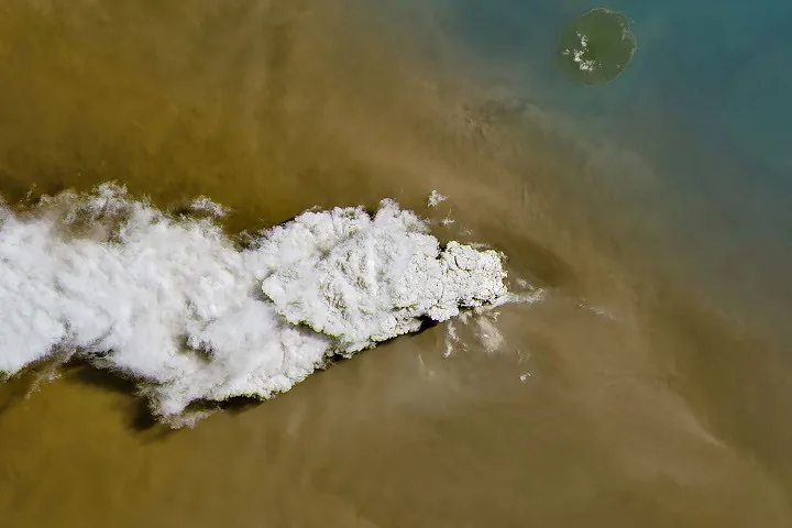
NASA’s Landsat 8 satellite captured the erupting volcano on September 5, 2026, with its Operational Land Imager showing white volcanic gas billowing above a brown ash cloud. The colours distinguish visible features. A wider view from the Suomi NPP satellite’s Visible Infrared Imaging Radiometer Suite traced volcanic material across the surrounding region, documenting the plume beyond the island. Lindsey Doermann’s Earth Observatory account describes sustained explosive activity lasting more than 24 hours. [1]
Indonesia’s meteorological agency, BMKG, reported ash reaching up to 6,000 metres east of the volcano and 15,000 metres westward by September 6, according to NASA’s account of its monitoring. Heights differed by location. Those figures do not describe a uniform ceiling over the entire ash cloud. NASA lists BMKG’s September 6 monitoring update among its references; the agency’s observations here come through that secondary account. The satellite scenes show the plume’s appearance and geographical reach, while BMKG’s reported heights add another dimension to the dispersal. Neither account supplies the total erupted volume or the quantity of magma still stored beneath the volcano. [1, 8]
Landsat photographed an eruption already underway. The image alone cannot establish whether a larger event will follow.
Why Did Airports Close?
Authorities temporarily closed eight airports on Java and Sumatra as airborne ash spread, while NASA cites news reporting for the nearly 3,000 flights disrupted across the region. Aircraft face specific hazards. Heather Handley, writing in The Conversation, explains that tiny, abrasive rock fragments can scratch windscreens, reduce visibility and cause engines to stall. She reports disruption affecting more than 300,000 passengers. Flight and passenger totals count different consequences of the Anak Krakatau eruption. [1, 2]
The Indonesian Humanitarian Coordination Platform reported ashfall in Jakarta and other parts of West Java, especially east of Anak Krakatau, in the September 6 situation report cited by NASA. The ash cloud also reached populated areas. NASA relays the platform’s distinction between volcanic ash and smoke from concurrent peatland fires: their particle characteristics, dispersal and appropriate protection measures differ. These observations draw on NASA’s summary of the platform’s report. [1, 9]
Handley identifies inhalation, eye irritation and skin irritation as ash hazards, although her account does not quantify illness caused by this particular eruption or provide a measured exposure assessment. Indonesia’s disaster management agency also attempted weather modification, spraying water mist from aircraft to encourage rain and remove ash. Effectiveness remains unquantified in her report. The operation’s stated aim therefore cannot establish how much ash it actually removed. [2]
What Triggered Krakatau in 1883?
Krakatau sits above a subduction zone (where one tectonic plate descends beneath another), with the Indo-Australian plate moving beneath the Eurasian plate and producing gas-rich magma. Handley connects this setting with explosive Indonesian volcanism. The trigger remains debated. Scientists once emphasised seawater entering the volcanic system, but deposits from May 1883 also preserve clues to interactions between different magmas before the most destructive phase. [2]
Handley describes pale pumice beneath darker grey ash, with chemical differences between the layers suggesting that fresh, hot magma may have entered a reservoir containing more viscous material. Mixing adds heat and gas. Under this interpretation, magma recharge helped destabilise the system, although researchers still debate the main triggers at different eruption stages. The deposits support a proposed mechanism without settling every stage of the eruption. The explanation concerns the historical system; the September satellite images do not establish an equivalent underground sequence today. [2]
Madden-Nadeau and colleagues’ 2021 study integrates field observations and crystal-scale evidence to examine the magmatic and eruptive evolution of Krakatau’s 1883 caldera-forming eruption, providing the primary research context. Morgavi and colleagues review magma mixing as an eruption trigger in their 2017 book chapter. Both address underlying processes. How far can those historical mechanisms explain the present Anak Krakatau eruption? The supplied observations leave the current magma system unresolved. [3, 4]


Why Were the Tsunamis So Destructive?
Handley attributes more than 90% of roughly 35,000 deaths in 1883 to tsunamis generated by volcanic collapse and pyroclastic flows (avalanches of hot gas, ash and rock). Krakatau’s marine setting mattered. The surrounding ocean carried the consequences towards distant coasts. Her account places waves along Australia and New Zealand, with heights exceeding two metres at several Australian locations. Falling volcanic material was only part of the disaster’s reach. [2]
At Geraldton in Western Australia, witnesses described the sea retreating before water rushed back, while eruption sounds elsewhere resembled “artillery at a distance,” according to historical reports recounted by Handley. She records no human deaths in Australia. Pumice travelled farther still. Floating volcanic fragments crossed the Indian Ocean and reached Zanzibar by July 1884, months after the explosive episode, extending the movement of eruption debris into the following year. [2]
Anak Krakatau’s 2018 eruption caused most of its roughly 300-metre-high structure to collapse and generated a tsunami that killed more than 400 people, Handley reports. The volcano has remained relatively small since. A collapse-generated tsunami is a documented hazard here. The earlier disaster establishes a mechanism, but assessing whether it could recur requires information about the present structure rather than an assumption that each eruption follows the same sequence. [2]
How Did Krakatau Cool the Climate?
Krakatau’s 1883 eruption sent gases and fine particles high into the atmosphere, where suspended material affected light for months and atmospheric reactions converted sulphur dioxide into sulphate aerosols (small airborne particles). Sunlight reaching the surface declined. Handley’s account gives approximately 0.3°C of near-surface cooling for several subsequent years, alongside unusual sky colours and a blue-looking Moon. The historical atmosphere responded through processes that extend beyond the visible ash cloud. [2]
Robock’s 2005 paper examines cooling after large eruptions with corrections for diffuse radiation effects on tree-ring evidence, while Harvey and Grab’s 2022 study examines Southern Hemisphere temperature responses in CMIP5 models. Their subjects differ. One addresses interpretation of an observational record; the other examines modelled continental responses to major eruptions since 1883. Neither citation supplies a cooling forecast for the Anak Krakatau eruption in September 2026. The contemporary reporting provides no comparable temperature estimate, so applying the historical 0.3°C figure to this event would exceed the evidence. [5, 7]
Could Another Major Disaster Follow?
NASA reports that sustained explosive activity eased on September 6 and gave way to Strombolian eruptions, intermittent bursts of ash and other volcanic material that represent a more typical pattern here. The volcano kept rumbling. Airports had resumed operations by September 8, but Anak Krakatau remained at Indonesia’s second-highest alert level, where it had stood since early July. Airport reopening did not mark the end of volcanic activity. [1]
Handley reports that Indonesia’s National Disaster Management Agency, BNPB, currently assesses the relatively small volcano as lacking the collapse potential needed to trigger a tsunami on that basis. This is the agency’s assessment. Repeated eruptions may destabilise the structure, while also limiting the longer-term accumulation of viscous magma; Handley presents both possibilities without predicting another 1883-scale disaster. Her DOI-linked version is listed as a preprint and has not undergone peer review. It provides no independent confirmation of BNPB’s current assessment. [2, 6]
Scientists cannot derive a timetable for the next major Anak Krakatau eruption from these satellite scenes. What happens after this episode remains open. BNPB directs affected communities towards government information as the volcano’s condition develops. [2]
- WEBSITE Doermann, L. (2026, September 9). Anak Krakatau rumbles again. NASA Earth Observatory. [Article Link]
- ONLINE NEWS Handley, H. (2026, September 9). Anak Krakatau is erupting. In 1883, Krakatau was devastating – could that happen again? The Conversation. [Article Link]
- ACADEMIC JOURNAL Madden-Nadeau, A., Cassidy, M., Pyle, D., Mather, T., Watt, S., Engwell, S., Abdurrachman, M., Nurshal, M., Tappin, D., & Ismail, T. (2021). The magmatic and eruptive evolution of the 1883 caldera-forming eruption of Krakatau: Integrating field- to crystal-scale observations. Journal of Volcanology and Geothermal Research, 411, 107176. [Article Link]
- BOOK CHAPTER Morgavi, D., Arienzo, I., Montagna, C., Perugini, D., & Dingwell, D. B. (2017). Magma mixing: History and dynamics of an eruption trigger. Advances in Volcanology, 123–137. [Article Link]
- ACADEMIC JOURNAL Robock, A. (2005). Cooling following large volcanic eruptions corrected for the effect of diffuse radiation on tree rings. Geophysical Research Letters, 32(6). [Article Link]
- PREPRINT Handley, H. (2026). Anak Krakatau is erupting. In 1883, Krakatau was devastating – could that happen again? [Preprint; version of source 2, not independent corroboration]. [Article Link]
- ACADEMIC JOURNAL Harvey, P. J., & Grab, S. W. (2022). Southern Hemisphere continental temperature responses to major volcanic eruptions since 1883 in CMIP5 models. Theoretical and Applied Climatology, 147(1–2), 143–157. [Article Link]
- REPORT BMKG. (2026, September 6). BMKG terus pantau dampak erupsi Gunung Anak Krakatau [Monitoring update, as cited in Doermann, 2026; original not consulted. Link leads to NASA’s citing account]. [Article Link]
- REPORT Indonesia Humanitarian Coordination Platform. (2026, September 6). Anak Krakatau eruption, volcanic ashfall and concurrent forest fire & haze situation [Situation report, as cited in Doermann, 2026; original not consulted. Link leads to NASA’s citing account]. [Article Link]
APA 7: PerEXP Teamworks. (2026, September 9). What the Anak Krakatau eruption reveals about its hazards. https://perexpteamworks.com/en/anak-krakatau-eruption/


