




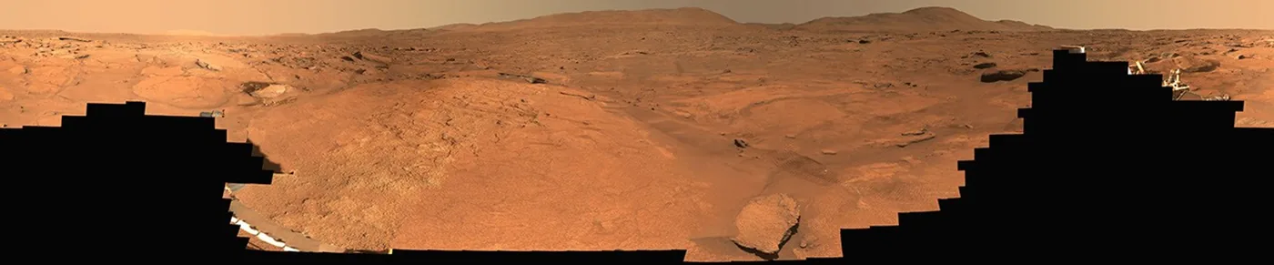
Can high-resolution orbital and surface imaging finally expose the ancient water history of Jezero Crater? A newly released Perseverance rover view offers an unprecedented look at Turquoise Bay, an intriguing geologic feature nestled within the crater’s Margin Unit. Stitched from 818 separate Mastcam-Z exposures taken across eleven Martian sols in October 2023, the full 360-degree panorama provides planetary scientists with an expansive survey of Martian bedrock [1].
How Mastcam-Z Built the Panorama
Deep space imaging demands precision. NASA operators commanded the dual-camera Mastcam-Z system to systematically document the Turquoise Bay workspace between Oct. 5 and Oct. 16, 2023. These operational dates corresponded directly to the 933rd to 944th Martian days, or sols, of the rover’s mission across the ancient lakebed [1].
Assembling 818 separate photographic frames into a seamless 360-degree composite required engineers to compensate for shifting shadows and changing atmospheric clarity across eleven sols. The task was demanding. Because Perseverance rested on an uneven Martian surface, camera elevation angles had to align perfectly across each individual frame to eliminate optical distortions along the distant horizon [2].
Image processing specialists generated two distinct deliverables from this campaign: a true natural-color mosaic and an enhanced-color version designated as Figure A. Data volume was massive. Each calibrated composite was archived under catalog entry PIA26815 as an uncompressed TIFF file (weighing 5.14 GB per file), giving researchers an extraordinarily detailed Perseverance rover view of Martian geologic stratification [3].
Where Turquoise Bay Sits in Jezero
Target selection was deliberate. Science planners designated Turquoise Bay as an informal geological field target situated along the inner margin of the crater where ancient water once flowed. Positioned directly inside the Margin Unit, this exposed terrain features ancient structural strata that formed when surface water actively shaped the Martian landscape. Bedrock exposures throughout this sector record the environmental conditions that governed the regional lakebed during its wettest climatic phases [2].
The Margin Unit represents a pivotal transition zone where fine-grained lacustrine sediments meet prominent carbonate-bearing rock formations. Carbonate minerals hold immense scientific value because they precipitate in neutral aqueous environments and possess the unique chemical capability to fossilize microscopic organic structures. Planetary researchers previously emphasized this potential when Perseverance gathered rock cores from the Martian lakebed to preserve evidence of ancient habitability. Every outcrop matters. By acquiring a comprehensive Perseverance rover view across this boundary, mission navigators can identify stable paths toward the most promising mineral outcroppings [2].
Why did mission planners choose to halt exploration at this specific boundary? Navigating the rover across uneven bedrock involves substantial risks of wheel slippage and hardware wear. Detailed surface panoramas help path planners chart safe traverse routes between boulder fields while simultaneously allowing geochemists to assess rock hardness from a distance [4].
Why Enhanced Color Reveals Mineral Clues
Human vision perceiving the Martian landscape under natural illumination registers a predominantly uniform expanse of rust-red oxidized dust covering dark volcanic basalt. To overcome these sensory constraints, image specialists at Arizona State University processed multispectral color bands to produce the enhanced-color version cataloged as Figure A. Researchers use this computational calibration to exaggerate subtle spectral variations across separate rock strata, transforming what appears to be ordinary gravel into a diagnostic geological map. Iron oxides, hydrated clay minerals, and carbonate veins reflect distinct wavelengths of light that become visibly discernible once false-color processing expands contrast across adjacent spectral channels. Through these enhanced Mastcam-Z mosaics, planetary geologists can distinguish weathered surface coatings from freshly exposed bedrock without requiring the rover to grind into every rock target directly [2].
Color variations reveal chemistry. By examining tonal shifts in Turquoise Bay, geologists selected promising sampling sites [1].
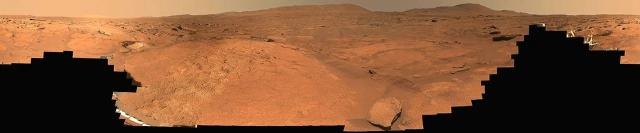
Every pixel in the enhanced mosaic represents calibrated radiometric reflectance rather than an artistic interpretation. Mastcam-Z operators rely on precise mathematical ratios between narrow infrared and visible light channels (specifically targeted mineral absorption bands) to trace hydrated clay formations across the exposed bedrock of Jezero Crater. For science teams examining the Margin Unit, this spectral differentiation provides direct clues about the historical presence of standing water and dissolved salts [2].


Perseverance Rover View Maps Key Boundaries
Surface mosaics like PIA26815 serve a dual operational role on Mars: they act as navigational charts for rover drivers and as regional surveys for stratigraphers. While orbiters photograph broad terrain features from hundreds of kilometers above, only a ground-level Perseverance rover view can resolve individual sediment laminae and pebble alignments. Understanding how atmospheric winds and ancient climates interact on arid planets often requires comparisons with terrestrial tropics, where solar radiation patterns similarly drive large-scale environmental changes. Ground observations enable researchers to trace ancient shoreline dynamics across Jezero Crater with millimeter precision [2].
Field observations conducted across sols 933 to 944 revealed distinct rocky benches sloping gently toward the central floor of Jezero Crater. Geologists classify these structural features as sedimentary shelves formed by fluctuating lake margins. By mapping the boundaries of Turquoise Bay within the Margin Unit, researchers can estimate how long liquid water persisted before the basin transformed into a frozen, hyper-arid desert [1].

Can a single panoramic survey resolve longstanding debates regarding Martian paleolakes? While surface mosaics cannot replace chemical assays, they establish the spatial framework required to contextualize subsequent drill cores. Each calibrated Perseverance rover view documents the exact physical relationships among adjacent rock strata before robotic arms initiate rock abrasions [5].
Who Built the Imaging Pipeline
Creating a complex visual survey like the Turquoise Bay mosaic relies on an extensive, multi-institutional operational pipeline that coordinates data streams across multiple university laboratories and aerospace research centers. Robotic leadership requires seamless cooperation. NASA’s Jet Propulsion Laboratory, managed by Caltech in Pasadena, California, built the Perseverance rover and oversees daily robotic activities on Mars. Meanwhile, Arizona State University leads Mastcam-Z instrument operations, coordinating daily camera pointing sequences and downlink telemetry [1].
Camera hardware development and color calibration depend on specialized institutional partners. Malin Space Science Systems in San Diego handled the design, fabrication, and hardware testing of the dual Mastcam-Z camera heads mounted on the rover’s remote sensing mast. Across the Atlantic, the Niels Bohr Institute at the University of Copenhagen designed and manufactured the onboard radiometric calibration targets (circular ceramic discs mounted on the rover deck) that enable true-color correction under varying Martian skies. When Anil Natha and Rafael Alanis documented the release for NASA Science, they emphasized how this multi-tiered engineering collaboration ensures that transmitted raw bytes translate into scientifically rigorous imagery. Without these meticulously engineered reference targets mounted on the deck, atmospheric haze and suspended mineral dust would severely distort the true radiometric reflectance properties of ancient Martian rocks [1].

International calibration targets proved vital. Without ground-verified reflectance standards, subtle spectral differences between carbonates and volcanic silicates could easily be misidentified by analysis software. Rigorous radiometric verification ensures that every published Perseverance rover view maintains true scientific integrity across international planetary research communities [6].
What Comes Next for Jezero Samples
While public attention often regards planetary panoramas as striking landscape postcards, mission scientists treat Turquoise Bay as an operational sampling roadmap. Perseverance continues its systematic campaign within the Margin Unit, seeking fine-grained rock layers suitable for robotic drill core extraction. The mission’s central scientific objective focuses on sealing core samples inside titanium tubes (stored securely within the rover body) for retrieval by future Earth return missions [2].
Educational analyst Ajit Kumar emphasized that regional surface panoramas provide the crucial geological context required to interpret returned Martian samples. Context transforms raw chemistry into planetary history. Without visual orientation data, laboratory researchers on Earth would struggle to understand whether an extracted mineral formed in quiet lacustrine depths or within energetic alluvial channels. By integrating this latest Perseverance rover view into the overarching geologic map of Jezero Crater, scientists ensure that each cached core retains its full environmental provenance [7].
Exploration continues along the crater rim. As the robotic rover advances toward new target formations, researchers will continue analyzing the 818 individual frames that document Turquoise Bay. Future investigations must determine whether these prominent carbonate beds accumulated across millions of years in a stable lake or precipitated abruptly during episodic floods. Until return missions deliver Martian rock cores directly to terrestrial laboratories, panoramic surveys serve as humanity’s primary record of Jezero’s ancient aqueous environments [1].
- PRESS RELEASE Alanis, R., & Natha, A. (2026, September 21). Perseverance’s view of ‘Turquoise Bay’. NASA Science. [Article Link]
- ONLINE NEWS BedrockNews. (2026, September 21). Perseverance stitches 818 photos into a Martian panorama that earns the name ‘Turquoise Bay’. BedrockNews. [Article Link]
- ONLINE NEWS PressBee. (2026, September 21). Perseverance’s view of ‘Turquoise Bay’. PressBee. [Article Link]
- ONLINE NEWS VibeWire Magazine. (2026, September 21). Perseverance’s view of ‘Turquoise Bay’. VibeWire Magazine. [Article Link]
- ONLINE NEWS Independent Space News. (2026, September 21). Perseverance’s view of ‘Turquoise Bay’. Independent Space News. [Article Link]
- ONLINE NEWS Aurora You. (2026, September 21). Perseverance’s view of ‘Turquoise Bay’. Aurora You. [Article Link]
- WEBSITE Kumar, A. (2026, September 22). Perseverance’s view of ‘Turquoise Bay’. Explore Education. [Article Link]
APA 7: TWs Editor. (2026, September 22). Perseverance Rover View Captures Turquoise Bay in Jezero Crater. PerEXP Teamworks. https://perexpteamworks.com/en/perseverance-rover-view-turquoise-bay/


