






How do microscopic airborne particles and stratospheric winds shape the everyday forecast? Atmospheric scientists are transforming weather prediction by deploying advanced aerosol simulations to resolve elusive atmospheric dynamics [1]. Aerosols (microscopic solid particles and liquid droplets suspended in Earth’s atmosphere) alter how clouds develop and how solar radiation warms the surface. Recent computational models that assimilate satellite radiances cut aerosol prediction errors by about 50 percent [2].
- How Do Aerosol Simulations Improve Weather Forecasts?
- Why Atmospheric Particles Complicate Climate Models?
- Direct Satellite Radiance Assimilation for Aerosol Simulations
- Artificial Intelligence Accelerates Aerosol Modeling
- Stratospheric Wave Predictability Unlocks Winter Cold Signals
- Connecting Atmospheric Layers to Refine Seasonal Predictions
How Do Aerosol Simulations Improve Weather Forecasts?
Aerosol simulations improve weather forecasts by providing numerical models with accurate spatial distributions of airborne particles that govern solar radiation and cloud formation. For decades, atmospheric models struggled to account for the minute interactions between suspended particles and incoming sunlight, leaving meteorologists with persistent uncertainties in both temperature and precipitation outlooks. When predictive algorithms integrate precise aerosol concentrations, simulated weather patterns align far more closely with observed conditions in multiple climate zones [2].
Predicting atmospheric changes involves calculating how light scatters through complex mixtures of dust, smoke, and industrial haze. Standard numerical frameworks rely on simplified assumptions that group particulate varieties into broad statistical averages, which distorts simulated heating rates in the lower atmosphere. By refining these calculations through high-resolution data streams, new forecasting platforms generate more dependable five-day and ten-day projections for local communities [1].
Accurate particulate tracking also influences how meteorologists estimate storm development and local air quality hazards. In an analysis reported by science editor Gaby Clark and senior editor Robert Egan for Phys.org, atmospheric researchers showed that tiny suspended particles travel over open oceans, subtly modifying cloud microphysics along their path. While earlier research investigated how marine bacteria and atmospheric rivers help create ice clouds through localized biological nucleation, this modeling framework resolves continental aerosol transport and satellite radiation assimilation across broader climate regimes [2].
Why Atmospheric Particles Complicate Climate Models?
Atmospheric particles complicate climate models because their chemical composition, geographic distribution, and optical behavior vary dramatically over time and space. These airborne substances come in many varieties, including wildfire smoke, pollen, desert dust, volcanic sulfates, and sea salt lofted by powerful storms, and emissions discharged by combustion engines and heavy industrial manufacturing plants [2]. Each particulate variety interacts with solar energy differently, with some scattering sunlight back into space to induce cooling while others absorb radiation and warm surrounding air layers [1].
In addition to altering radiative energy budgets, suspended particles serve as microscopic collection points where water molecules condense to initiate cloud development. These microscopic interactions govern cloud reflectivity and precipitation efficiency, meaning that small fluctuations in particle abundance can alter rainfall patterns over whole continents. Because individual aerosols drift across disparate atmospheric layers and traverse thousands of miles over open oceans, tracking their lifecycle requires modeling chemical reactions alongside continental wind currents [2].

Simulating such intricate phenomena historically strained available computing power. Capturing the full life cycle of particulate plumes involves simulating tiny chemical reactions while also resolving planetary air currents across thousands of miles. That enormous scale disparity creates heavy computational friction in global climate modeling, highlighting the practical necessity of scalable aerosol simulations that run efficiently on operational systems [3].
Direct Satellite Radiance Assimilation for Aerosol Simulations
Satellite observations have long provided essential empirical data used to monitor particulate distributions from Earth orbit. Instruments onboard polar-orbiting satellites track aerosol plumes by detecting sunlight reflected by particles, yet integrating raw observations into numerical forecasting models proved too computationally demanding for weather centers. Most forecasting centers relied instead on preprocessed data products that approximate aerosol properties indirectly, sacrificing forecasting accuracy in exchange for computational feasibility [1].
To eliminate this trade-off, a research team led by Chongzhao Zhang introduced a computationally efficient methodology for direct assimilation of satellite visible and near-infrared radiances into aerosol simulations. Publishing their framework under DOI 10.1029/2026ms005846 in the Journal of Advances in Modeling Earth Systems, Zhang and his co-authors proved that raw radiances could be ingested without computational bottlenecks. The breakthrough allows numerical models to exploit orbital data streams at their native spectral fidelity, a development highlighted by Eos and hosted by the American Geophysical Union [2].
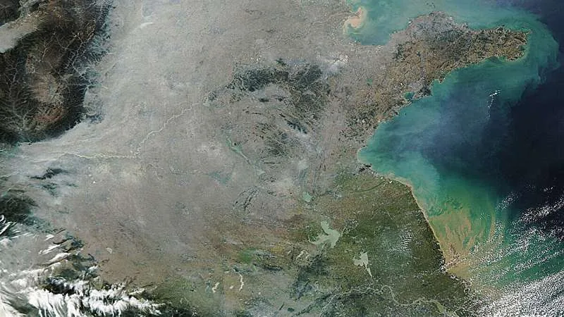
Real-world satellite data show the practical necessity of such precision. In October 2024, NASA’s satellite-mounted Moderate Resolution Imaging Spectroradiometer (MODIS) captured a dense aerosol haze hanging over eastern China, as documented by the MODIS Land Rapid Response Team at NASA GSFC. Earlier reporting detailed similar environmental pressures in an investigation of wintertime pollution particles in China’s skies, showing that ground-level emissions demand ongoing orbital monitoring to safeguard public health [3].


Artificial Intelligence Accelerates Aerosol Modeling
The foundational breakthrough enabling this direct assimilation workflow is an artificial intelligence (AI) component engineered to calculate radiative transfer in real time. Pretrained on a broad dataset of atmospheric states, the machine learning module instantly determines how raw satellite radiance readings reflect the coupled interactions between airborne aerosols and sunlight bouncing off Earth’s complex surface [1]. By replacing cumbersome numerical solvers with neural inference, the research team bypassed the major computational bottleneck that long hindered atmospheric radiance assimilation [2].
When evaluated against real-world observations over China, the new simulation system achieved remarkable gains in predictive fidelity. The research team found that incorporating raw satellite radiances reduced aerosol prediction errors by about 50 percent compared with conventional aerosol simulations [1]. Sarah Stanley reported for Phys.org that this error reduction confirms the technique’s potential as a scalable pathway to refine weather forecasts and climate projections [2].
Bridging machine learning and atmospheric physics marks a pivotal shift in environmental forecasting. Rather than relying on rigid statistical simplifications, forecasting centers can now leverage neural algorithms to process unbroken orbital observations. Zhang and his collaborators have provided a practical blueprint for integrating high-volume satellite data into daily models without demanding supercomputing clusters beyond the reach of standard meteorological agencies [1].
Stratospheric Wave Predictability Unlocks Winter Cold Signals
While microscopic particles govern lower-atmospheric processes, planetary-scale waves operating miles above the surface dictate extended weather horizons. In a landmark study published in Science Advances, lead author Xiuyuan Ding of Princeton University’s Program in Atmospheric and Oceanic Sciences identified a hidden stratospheric signal that improves week-two winter forecasts over North America [4]. Working with co-authors at NOAA’s Geophysical Fluid Dynamics Laboratory, UCLA, and the University of Virginia, Ding discovered that a massive stratospheric wave pattern creates a predictable window for anticipating deep cold snaps [5].
The research team analyzed past weather data using SPEAR, an advanced forecasting model developed at GFDL that couples atmospheric, oceanic, terrestrial, and sea ice dynamics. SPEAR evaluated retrospective forecasts for 20 past winters from 2000 through 2019, initiating new ten-member forecast cycles every five days. Looking for predictable patterns in the lower stratosphere, where air patterns stay forecastable for roughly 20 days (about two to three weeks), the scientists identified a hemispheric wave-1 configuration characterized by high pressure over North America and matching low pressure over Eurasia. When this massive high-altitude wave builds up, energy ripples downward to the surface over the following days, creating an atmospheric bridge that alters ground temperatures over thousands of miles [5].

To verify the pattern’s past reliability, researchers examined weather reconstructions from the European Centre for Medium-Range Weather Forecasts (ECMWF) dating from 1950 to 2021. The wave-1 pattern strengthened 138 times in the ECMWF archive, with 39 events occurring during the 2000 to 2019 study period. “About a week later, the circulation tends to evolve toward a pattern that favors cold conditions over North America,” Ding said. Observational records confirmed that in 77 percent of those 39 recent events, North America experienced colder-than-normal conditions during the second week [5].
Connecting Atmospheric Layers to Refine Seasonal Predictions
By comparing 41 forecasts initiated after wave events against 679 ordinary winter cycles, Ding and his colleagues documented notable statistical gains. Week-two temperature forecasts for central Canada and the U.S. Midwest matched observed conditions approximately 15 percent better, with accuracy gains falling between 2 percent and 28 percent after adjusting for chance. Crucially, that geographic region is home to over 69 percent of Canada’s population and more than 30 percent of the U.S. population, meaning the enhanced predictability benefits tens of millions of residents exposed to winter extremes [5].
The forecasting advantage was especially pronounced during sharp temperature drops, where the match between predicted and observed extreme cold days improved by 28 percent. Unlike sudden stratospheric warmings that disrupt the circumpolar vortex over the North Pole, this wave-1 mechanism transfers energy downward through atmospheric layers along an entirely independent pathway. Similar predictive improvements emerged in three separate forecasting frameworks, including ECMWF’s global model, confirming that the dynamic is a genuine feature of the climate system [5].
Despite these promising findings, real-world deployment calls for further refinement before forecasters can integrate both stratospheric signals and advanced aerosol simulations in real time. “Our results do not translate into a fixed number of extra forecast days in every situation,” Ding said, explaining that the dynamic offers a clear window of opportunity rather than an automatic extension of forecast skill. “The basic ingredients are already available because forecasting systems routinely predict the stratosphere,” Ding said. “However, our study is based on retrospective forecasts, so this is not yet an operational forecasting tool. Real-time implementation is still further off.” [5]
- ACADEMIC JOURNAL Zhang, C., Li, Q., Li, J., Han, W., Zhang, Y., Chen, S., Zhang, Z., Dong, Y., Chang, L., & Li, J. (2026). Direct Assimilation of Satellite Visible and Near‐Infrared Radiances to Improve Aerosol Simulations. Journal of Advances in Modeling Earth Systems, 18(9). [Article Link]
- ONLINE NEWS Stanley, S. (2026, October 2). Scientists zero in on tiny particles to improve weather and air quality forecasts. Phys.org. [Article Link]
- ONLINE NEWS American Geophysical Union. (2026, October 2). Scientists zero in on tiny particles to improve weather and air quality forecasts. Eos. [Article Link]
- ACADEMIC JOURNAL Ding, X., Xiang, B., Chen, G., & Wang, L. (2026). Stratospheric wave predictability enhances surface forecasts over North America. Science Advances, 12(38). [Article Link]
- ONLINE NEWS Arrais, L., & Ralls, E. (2026, October 3). Scientists find a hidden signal that could improve winter forecasts. Earth.com. [Article Link]
APA 7: PerEXP Teamworks. (2026, October 4). How Aerosol Simulations Refine Weather and Climate Forecasts. PerEXP Teamworks.


