




How much ice remains tucked away in the highest peaks of the Rocky Mountains and the Pacific Northwest? Modern surveys of American West glaciers show that the frozen alpine landscape is shrinking much faster than cartographers previously documented. When geologists first drafted detailed national topographic maps during the mid-20th century, more than 1,450 glaciers covered the high ranges in six western states. Today, an updated inventory reveals that over 300 of those glaciers have vanished, reducing total regional glacier area by 35% [1].
- How Many Glaciers Disappeared in the American West?
- Where Did Western US Glaciers Suffer the Greatest Loss?
- Why Shaded Topography Shields Surviving Glacial Niches
- Geological Hazards Created by Retreating Volcano Glaciers
- Downstream Consequences for Streamflow and Alpine Ecology
- Distinguishing Modern Mountain Glaciers from Prehistoric Sea Ice
How Many Glaciers Disappeared in the American West?
More than 300 glaciers have disappeared from the western United States since the middle of the 20th century, according to comprehensive mapping led by Portland State University. Geologists compared historical topographic maps produced by the U.S. Geological Survey with satellite and aerial imagery gathered between 2013 and 2020. That mid-20th-century baseline documented glaciers covering 217 square miles (562 square kilometers) within six western states. The updated assessment, published in the Proceedings of the National Academy of Sciences, confirmed that overall glacier area shrank by 35% [2].
The census, led by Portland State University geology professor emeritus Andrew Fountain and research analyst Bryce Glenn in Earth System Science Data, identified 1,331 glaciers and 1,176 perennial snowfields. Perennial snowfields differ from active glaciers because their frozen bodies do not move and lack crevasses. The team also examined the 612 officially named glaciers listed in the federal Geographic Names Information System. They discovered that 52 of these named landmarks no longer meet the scientific definition of a glacier, which requires an extent of at least 0.01 square kilometers (roughly the size of two football fields side-by-side) and visible evidence of downslope motion. “Glaciers are disappearing and this is a quantification of how many around us have disappeared and will probably continue to disappear,” Fountain said [3].
Among those 52 named features, two disappeared completely: Milk Lake Glacier in Washington’s Mt. Baker-Snoqualmie National Forest and Wyoming’s Hooker Glacier in the Wind River Range. Another 25 were reclassified as perennial snowfields because their ice had stopped flowing, while 18 had shrunk below the size threshold. Seven formations were identified as rock glaciers, which are rock debris containing ice within pore spaces. Fountain said this quantification provides a baseline for tracking how alpine ice fields respond to rising global temperatures [4].
Where Did Western US Glaciers Suffer the Greatest Loss?
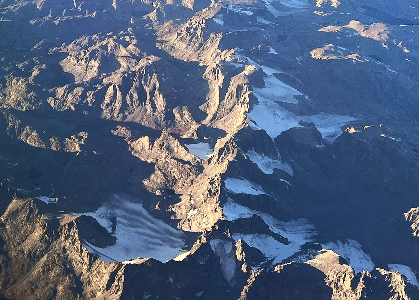
The fastest rates of ice loss occurred in the Rocky Mountains, led by the Beartooth-Absaroka Mountains of southern Montana [1]. Glaciers in this mountain range have been thinning by about 1.5 feet (half a meter) of ice thickness every year, losing mass much faster than peaks in the Pacific Northwest. Montana alone has lost 76 glaciers since the mid-20th century. Six officially named glaciers in the state failed to qualify in the updated inventory, including ice bodies in the Mission-Swan Range, the Crazy Mountains, the Cabinet Mountains, and the Lewis Range inside Glacier National Park. “It was always a relief to find that a glacier was still a glacier,” Fountain said, noting that his team cheered whenever aerial surveys proved that a remote ice body remained active [6].
In Oregon, researchers identified similar losses in the Cascade Range. Journalist Alex Baumhardt reported for Oregon Public Broadcasting that 25 glaciers vanished from the Cascades, including seven in Oregon, primarily clustered around the Three Sisters peaks. Oregon’s Benson Glacier in the Wallowa Mountains was reclassified as a snowfield. Fountain said that peaks south of Mount Hood could lose their remaining ice within 50 years, warning: “What this means is that our gorgeous summertime views of the mountains are going to become more like California, where they’re just kind of barren peaks” [7].
Washington state presents a different story because it holds the vast majority of glacier ice in the lower 48 states. Glaciers on Mount Rainier alone cover about 4.3 square miles (11.24 square kilometers), an area greater than the glacier total of all other western states combined. Mount Rainier and Mount Baker receive heavier winter snowfall and experience cooler maritime summers. While their glaciers are shrinking, they thin at a slower pace of about half a foot of ice thickness per year [1].
Why Shaded Topography Shields Surviving Glacial Niches
In a 2026 preprint awaiting formal peer review, Fountain explained why small glaciers in Colorado, Wyoming, Montana, and California have managed to persist despite warming temperatures. Outside of Washington, average glacier size in the West is only about one-tenth of a square mile (a quarter of a square kilometer). Surviving Rocky Mountain glaciers subsist because of their unique position on the landscape. They inhabit deeply shaded niches less exposed to direct sunshine and collect additional snow from avalanches that tumble down steep headwalls [1].
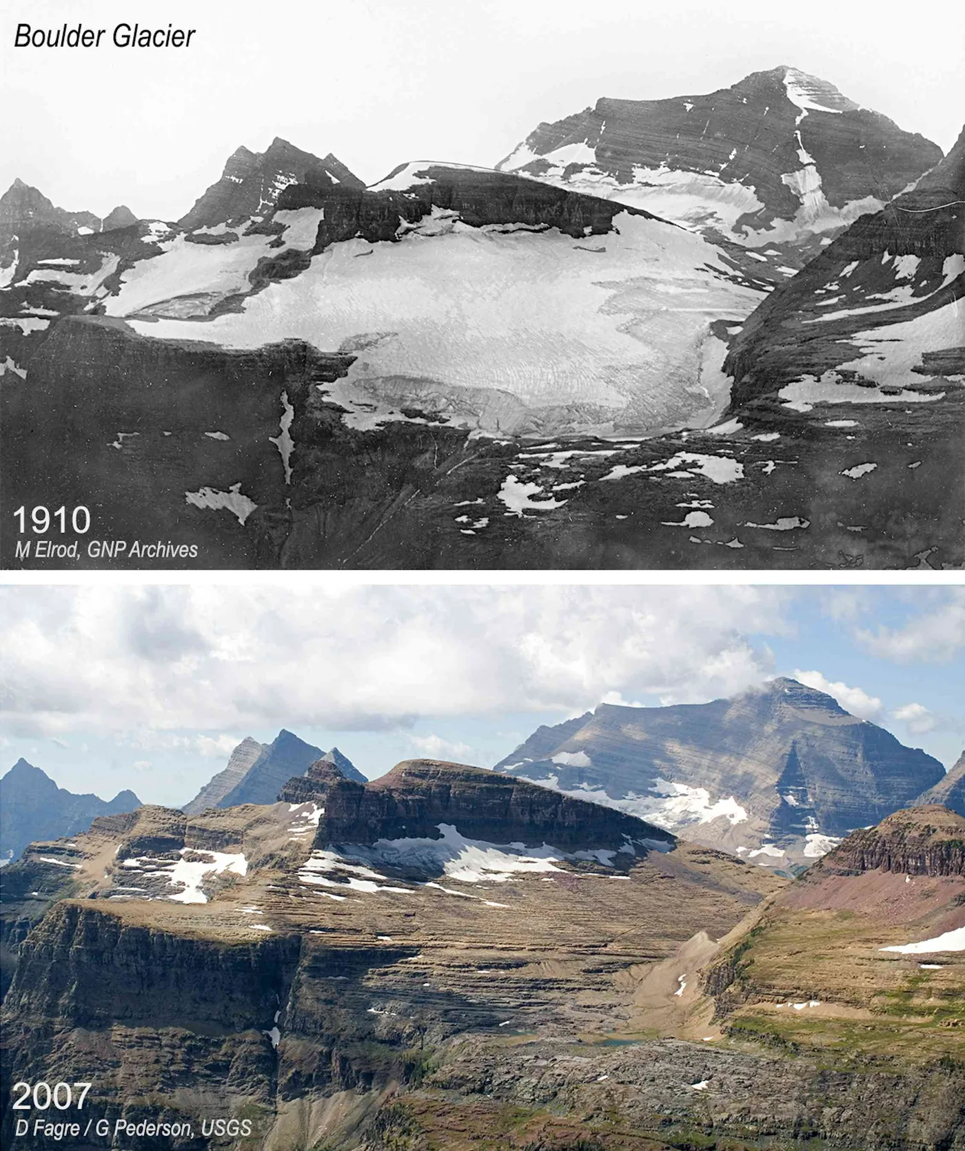
If these glaciers were exposed to more sunlight and less snow accumulation, they likely wouldn’t exist at all. Historical photographs of Montana’s Boulder Glacier between 1910 and 2007 demonstrate how ice clinging to shaded cliffs survived long after open ice melted away [1].
The only growing glacier in the American West is Crater Glacier on Mount St. Helens in Washington. Following the 1980 volcanic eruption, snow, rockfall, and ice rapidly accumulated on the shaded, north-facing interior crater wall. This young glacier continues to advance downslope because thick volcanic debris coats the ice surface, insulating it from warm summer air [7].

Geological Hazards Created by Retreating Volcano Glaciers
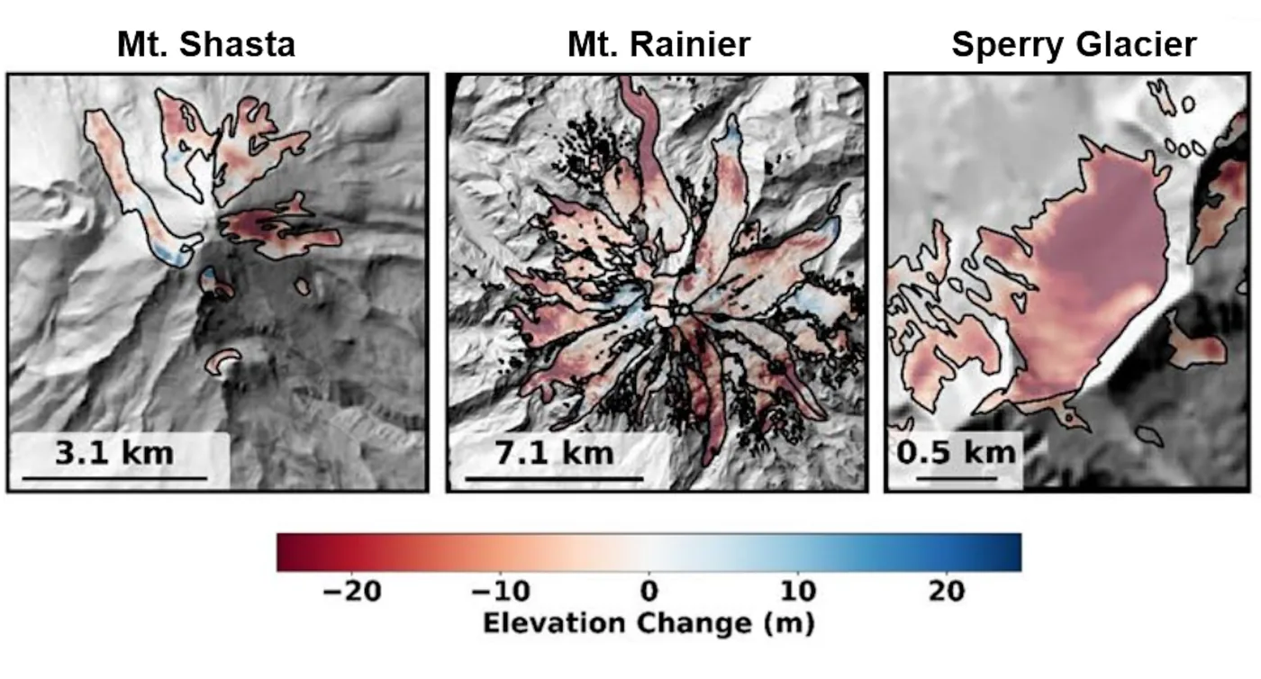
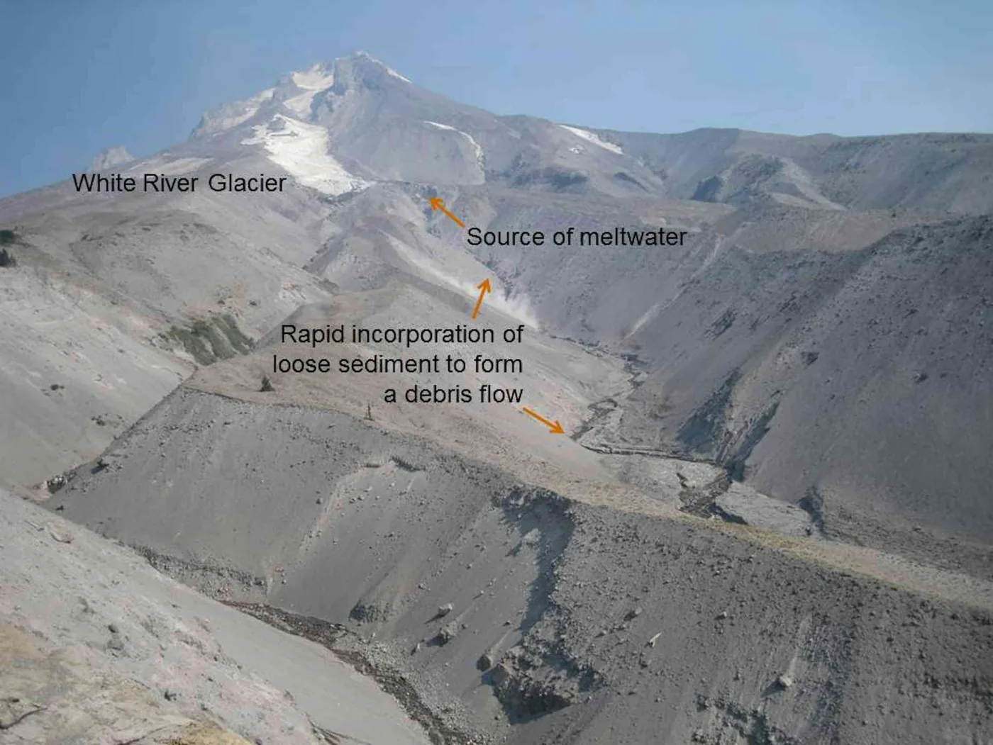
As glaciers retreat, they create physical hazards for downstream communities. Moving ice erodes surrounding bedrock and deposits aprons of loose rock called moraines at lower elevations. When glaciers melt back, they leave behind steep-sided moraines that are no longer buttressed by solid ice [1].
On the steep volcanoes of the Cascade Range, these loose moraines become dangerous sources of landslides and debris flows. High water flows from heavy autumn rainstorms or sudden summer meltwater can undercut the moraines, sending thousands of tons of rock and mud roaring down valleys. In 2006, debris flows on Mount Hood and Mount Rainier washed out mountain roads and forced highway closures [1].
Christopher McNeil, a geophysicist with the USGS Alaska Science Center, and Brian Menounos observed that steep embankments left by retreating glaciers can collapse without warning [2, 4]. Because highly erodible volcanic rock underlies many Cascade glaciers, retreating ice margins will likely generate debris flows more frequently as warmer summers weaken alpine slopes [1].
Downstream Consequences for Streamflow and Alpine Ecology
Alpine glaciers serve as frozen water reservoirs that regulate western river basins during the hottest weeks of the year. Glaciers melt heavily during dry summer periods and melt very little during rainy weather. They release cool water after seasonal snowpacks disappear, buffering mountain watersheds against seasonal drought [4].
Cold glacial meltwater is vital for stream ecosystems, keeping alpine creeks cool for cold-adapted fish and aquatic insects [1]. Agricultural communities also depend on this runoff. In Oregon’s Hood River Basin, pear and apple orchards receive irrigation water from the Middle Fork of the Eliot River, which is two-thirds glacial fed in late August and September [7]. Washington glaciers also contribute meltwater to regional hydropower production [1].
When mountain glaciers disappear, rivers lose this late-summer buffer. Unlike polar ice sheets where snowfall cannot halt locked Antarctic ice loss, temperate alpine glaciers are sensitive to local seasonal variations. Without regular glacial contributions, mountain streams face warmer temperatures and lower water levels that leave fish and farms vulnerable to severe summer shortages [1, 7].

Distinguishing Modern Mountain Glaciers from Prehistoric Sea Ice
Computer models created for Washington’s Olympic Peninsula indicate that most of its glaciers will disappear by 2070 under current climate trends. Because the Olympic Mountains stand close to the Pacific Ocean at lower elevations, their glaciers are especially vulnerable to rising freezing levels. Larger ice bodies on Mount Rainier and Mount Baker may survive past 2100, but their long-term future remains uncertain [1].
Glaciologists emphasize that modern mountain glaciers function very differently from the coastal ice sheets that covered the continent in prehistoric eras. Archaeological research has explored how ancient sea ice supported early human migration across North America by providing shoreline travel platforms 24,000 years ago during the height of the last ice age. Coastal sea ice expanded over thousands of square miles of ocean and shoreline, but surviving American West glaciers are isolated alpine remnants confined to narrow mountain cirques. Because these mountain glaciers are pinned to high elevations, they can’t shift their positions as temperatures rise [1].
Fountain pointed out that managing glaciers is complicated because no single agency oversees them: “Frankly, we’re all kind of on our own on this. There is no state agency that is particularly concerned with the glaciers. It kind of falls between geology and hydrology”. Without dedicated state oversight, scientists at Portland State University and the USGS must continue tracking these vanishing ice fields to record an alpine ecosystem undergoing rapid decline [4, 7].
- PREPRINT Fountain, A. (2026). 300 glaciers have disappeared from the American West since the mid-20th century – the survivors have a few things in common. The Conversation. [Article Link]
- ACADEMIC JOURNAL Fountain, A. G., Glenn, B., McNeil, C., & Menounos, B. (2026). Extensive glacier loss in the coterminous United States. Proceedings of the National Academy of Sciences, 123(43). [Article Link]
- ACADEMIC JOURNAL Fountain, A. G., Glenn, B., & McNeil, C. (2023). Inventory of glaciers and perennial snowfields of the conterminous USA. Earth System Science Data, 15(9), 4077–4104. [Article Link]
- ONLINE NEWS Portland State University. (2023). Alarming findings: Glaciers in the Western United States are disappearing. SciTechDaily. [Article Link]
- ONLINE NEWS Rojas, C. (2023). Glaciers are becoming smaller and disappearing, finds new inventory. Phys.org. [Article Link]
- ONLINE NEWS Franz, J. (2023). New research finds shrinking number of glaciers across the West. Montana Free Press. [Article Link]
- ONLINE NEWS Baumhardt, A. (2023). Oregon Cascades, Western states losing glaciers, new analysis finds. Oregon Public Broadcasting. [Article Link]
APA 7: TWs Editor. (2026, October 13). The Disappearance of 300 Glaciers in the American West. PerEXP Teamworks. https://perexpteamworks.com/en/american-west-glaciers-disappear-survey/


