



Does the open sky above rural farm country hold missing pieces in our understanding of atmospheric chemistry? Scientists know that livestock farms release potent trace gases into the air, but standard ground monitors can’t trace how these plumes disperse into the lower atmosphere. To measure agricultural emissions at their source, NASA launched a series of low-altitude flights over pastures and feedlots near Transit, Texas. While earlier work focused on general air basins, this targeted campaign studies immediate plume behavior under late autumn weather conditions. The research flights run from Thursday, Oct. 22, through Monday, Nov. 9 [1].
Why Track Agricultural Emissions From Low Altitudes?
Low-flying aircraft capture rising gases before atmospheric winds dilute or alter plume concentrations over farmland. Satellites orbiting hundreds of miles above Earth provide valuable planetary views, but they often struggle to detect subtle surface fluxes from isolated rural facilities. By cruising low above the terrain, flight crews can sample plumes while chemical mixtures remain concentrated in the boundary layer. Ground stations miss this aloft dispersion. This flight profile allows researchers to record real concentrations of volatile gases right as they leave animal pens and surrounding pastures [1].
Plumes from rural operations change rapidly when exposed to daytime solar heat, wind shear, and ambient moisture. Earlier findings on research flights tracking agricultural emissions in western valleys demonstrated that local land contours heavily influence how gases pool near the soil. Over the open plains near Transit, Texas, flat ground creates steady thermal updrafts during sunny afternoons, lifting trace gases into the lower troposphere before regional weather fronts can sweep them eastward. Afternoon heating accelerates this lofting process. Flying slow transects at low altitudes lets researchers measure these vertical transport rates directly, turning raw flight paths into detailed three-dimensional maps of farm pollution plumes [1].
Does NASA Conduct Research on Farm Emissions?
NASA regularly conducts airborne scientific research to understand how rural land use interacts with Earth’s broader atmosphere. While public attention often centers on deep space probes, the agency maintains an active fleet of research aircraft studying Earth as an integrated planetary system. Farm fields and livestock facilities produce large atmospheric inputs, but their collective influence on regional climate chemistry is still poorly documented. Earth science forms a core agency mandate. Flying aircraft equipped with sensitive gas spectrometers allows the agency to bridge the observational gap between surface monitoring stations and Earth-observing satellites [1].
Connecting airborne observations with surface ground truth also links into wider ecological programs, including crop health monitoring across agricultural zones that track seasonal plant stress. Measuring farm emissions from the air provides concrete data that university partners use to refine chemical transport models. Modelers depend on real airborne data. These models help scientists predict how rural gas releases drift toward populated areas, informing regional air quality forecasts without relying on rough mathematical estimates [1].
FarmFlux Deployment Over Transit Farmland
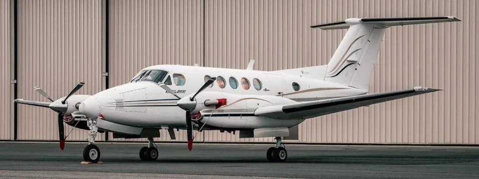
The airborne campaign centers its flight paths over rural pastures near Transit, Texas, where concentrated animal feeding operations supply strong gas plumes. Flight crews operate an A200 aircraft supplied by Dynamic Aviation, a twin-engine turboprop well suited for stable low-altitude survey lines. Flight operations began on Thursday, Oct. 22, and continue through Monday, Nov. 9. The flight window spans eighteen days. This schedule gives researchers repeated opportunities to sample plumes under varying wind conditions and autumn air temperatures [1].
Flight crews steer the aircraft through tight grid patterns downwind of major feeding pens to intercept rising air masses before they scatter into the surrounding sky. Animal feeding operations concentrate hundreds of livestock into localized feedlots, creating intense point sources of ammonia and methane that can spike local sensor readings within seconds. The pilots maintain steady speeds just above the treetop line, flying back and forth across each plume at multiple altitudes to capture its vertical structure. Autumn winds shift direction quickly over Texas pastures. By gathering air samples during morning cool periods and afternoon heat, the team observes how surface warmth accelerates gas release. These repeated flight legs produce clear profiles of how agricultural emissions disperse away from rural sources [1].
Which Sensors Measure Agricultural Pollutants?
The FarmFlux mission deploys an advanced sensor array to track multiple agricultural gases lifting off rural acreage. Flight instruments detect ozone and trace ammonia along with methane plumes escaping from feedlots, while optical particle counters record fine dust kicked up by livestock. Feedlots release complex chemical cocktails that behave differently from urban industrial smog. Methane escapes from livestock digestion and manure storage, while volatile ammonia evaporates from animal waste into warm air. Sunlight triggers secondary photochemical reactions. As these agricultural pollutants drift away from feedlots, solar ultraviolet rays trigger secondary chemical interactions that can create harmful ground-level ozone in rural communities [1].
The onboard instrument suite records continuous measurements as the aircraft slices through each invisible plume. Having more than a dozen sensors operating at the same time allows the science team to correlate spikes in ammonia with rises in fine particulates (tiny solid flecks and liquid droplets suspended in the air). When ammonia combines with atmospheric acids, it forms fine ammonium nitrate and ammonium sulfate particles that degrade rural air clarity. Airborne detectors deliver instant cockpit readouts. Real-time data readouts help flight operators steer into dense plume pockets, ensuring that no key chemical transition goes unrecorded during the flight [1].
Multi-Agency Leadership Behind the Mission
The FarmFlux research project relies on close cooperation among federal flight centers and university researchers. The mission is jointly led by NASA’s Goddard Space Flight Center in Greenbelt, Maryland, Colorado State University, and Boston University. Each team brings specific scientific assets to the effort: Goddard engineers oversee aircraft sensor integration and data systems, while university investigators contribute atmospheric modeling and ground-level chemical sampling protocols. University teams handle complex chemistry codes [1].
Science reporting for the flight series was issued by Sharon Teitelbaum and Gianine Figliozzi from NASA’s Ames Research Center in California’s Silicon Valley. Ames serves as the central news hub. Combining flight data with regional agricultural surveys helps environmental planners evaluate how seasonal weather alters local gas outputs. This interagency partnership helps field observations translate into better tools for managing rural air quality [1].
Future Flight Plans Over American Croplands
The flights over Transit represent only the opening chapter of the broader FarmFlux initiative. NASA has scheduled additional low-altitude research flights for the March to July 2027 growing season, shifting the scientific focus toward expansive crop acreage. This future phase will deploy a four-engine NASA P-3 Orion aircraft, a heavy turboprop that can carry larger instrument payloads over long survey routes in the American Midwest and California’s Central Valley. The larger plane handles longer survey tracks [1].
Shifting the investigation to the Midwest and California’s Central Valley in 2027 will allow scientists to compare feedlot emissions with gaseous releases from fertilized cropland. While livestock farms produce steady plumes of methane and ammonia year-round, fertilized grain and vegetable fields release seasonal pulses of nitrogen gases during spring planting and irrigation cycles. By contrasting these two farming regimes, researchers will construct a detailed picture of how agricultural emissions influence regional air quality and atmospheric chemistry. Soil biology drives different seasonal pulses. The resulting flight records will give atmospheric scientists reliable baseline numbers to evaluate future changes in rural land management [1].
- PRESS RELEASE Figliozzi, G., & Teitelbaum, S. (2026). NASA to Conduct Low-Altitude Flights Over Texas Farmland. NASA Ames Research Center. [Article Link]
Cover image: European Union, Copernicus Sentinel-2 imagery / Wikimedia Commons, Attribution
APA 7: PerEXP Teamworks. (2026, October 16). How FarmFlux Flights Track Agricultural Emissions in Texas.


