






Can tropical weather truly threaten the arid coastlines of the western United States? Most Americans rarely connect California with tropical storms, but the 2026 Pacific hurricane season has delivered an unusual run of damaging coastal weather that caught emergency crews and coastal residents off guard. National forecasters issued a tropical storm watch for Southern California from October 9 to October 11 as Tropical Storm Rachel pushed northward. It marked only the second time ever that federal forecasters issued such an alert for the area, following Hurricane Hilary just three years earlier [1].
Why Is the 2026 Pacific Hurricane Season So Active?
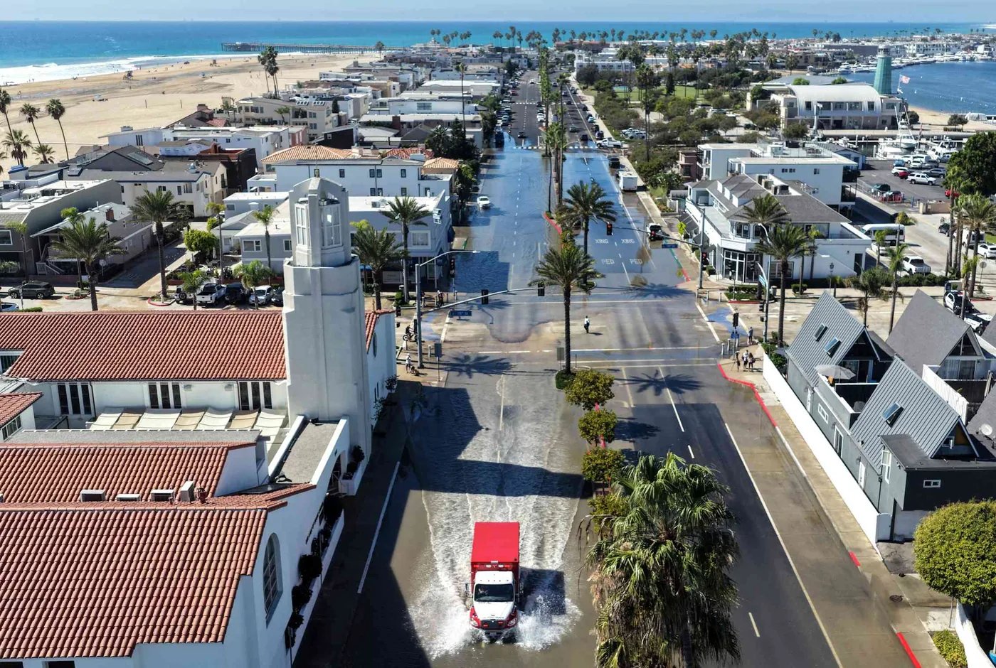
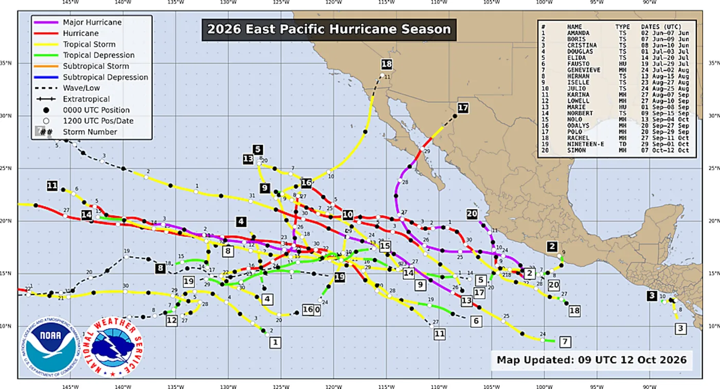
Coastal towns in the eastern Pacific experienced a remarkably busy run of late-season storms. The 2026 season departed from ordinary storm behavior by steering several organized tropical systems directly toward populated land areas that seldom face tropical cyclone winds, bringing drenching rain and coastal flooding into communities that lack the drainage infrastructure to handle subtropical downpours. Hawaii faced three separate hurricanes. Farther east, September brought high surf from Hurricane Marie that damaged oceanfront homes near Los Angeles before the core veered away [1].
Tropical Storm Rachel followed soon after, showing how an active Pacific hurricane season can impact California even after losing primary hurricane status. Forecasters tracked Rachel as it weakened into an extratropical cyclone before making landfall on the Baja California peninsula. Even with that weakening, the storm pushed powerful ocean swells into Southern California that damaged beachfront residences and flooded seaside roads while bringing high tides into low-lying harbor communities. Las Vegas streets flooded within hours [1].
A preprint study authored by researcher Nicholas Grondin explains how these back-to-back events placed unusual pressure on coastal communities. Because the study remains a preprint, it has not yet undergone peer review by independent scientists. Grondin notes that while tropical storm impacts in California are rare, they are not without historical precedent. His research indicates that abnormal ocean heat off the coast of Baja California played a key part in helping Rachel survive its northward path toward the American border [1].
California Encounters Rare Direct Storm Hits
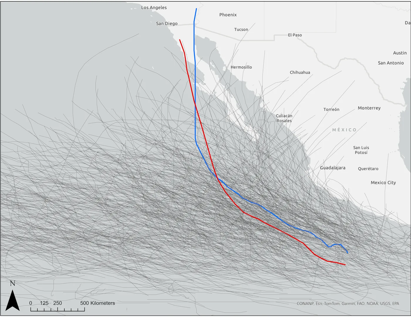
Historical climate records show that direct storm landfalls along the California shoreline remain exceptionally rare because cold coastal currents moving down from the north usually strip approaching cyclones of their heat source long before their circulating centers can strike the mainland. To find the earliest documented hurricane impact in the region, meteorologists look back to the 1858 San Diego Hurricane. The 1858 hurricane reached Category 1 strength [1]. It brushed the coast of San Diego County, bringing tropical-storm-force winds that caused building damage across a settlement that held only a small fraction of its current population.
The only documented tropical storm ever to make direct landfall on the California coast occurred eight decades later, in 1939. That system struck Long Beach in Los Angeles County, catching coastal residents completely by surprise with tropical-storm-force winds and torrential downpours. Rainfall exceeded 4 inches in some areas. The surprise disaster prompted the United States Weather Bureau, the agency that later became the National Weather Service, to open a Southern California office in 1940 in response [1].
Modern hazard studies show that a similar storm today would produce immense disruption across the Los Angeles metropolitan area. A 2004 research paper estimated that if a storm matching the 1939 event hit the region in the mid-2000s, it would likely cause over US$200 million in damage. While a few other tropical storms approached the California coast during the 1970s, each one weakened or changed course, avoiding a direct hit on land [1]. None made landfall in the state.
Historical Tropical Storms That Reached Southern California
Even when tropical systems stay offshore or make landfall in Mexico, their outer winds and moisture can reach California. In 1997, Hurricane Nora came ashore in Baja California and sent tropical-storm-force winds directly into the state. More recently, in 2023, the remnants of Hurricane Hilary caused flooding throughout Southern California while dumping 10 inches of rain across local mountain ranges. Hilary dropped 10 inches in the mountains [1]. That event showed that decaying tropical systems can dump immense amounts of moisture over dry terrain.
Open-ocean storms can also damage ports and piers without ever crossing the California coastline. Long-period swells traveling thousands of miles from deep water often batter exposed shoreline infrastructure. Recent years have seen several offshore systems generate damaging swells, including Hurricane Marie in 2024 and Hurricane Narda in 2025. When another Hurricane Marie formed in September 2026, its large waves again battered oceanfront homes near Los Angeles, eroding sandy bluffs and damaging private properties along the shoreline [1].
These Pacific storm impacts stand in sharp contrast to seasons where storm tracks stay far offshore. Climate researchers often compare these active periods with an analysis of quiet milestones in historical hurricane seasons that tracks long calms in the Atlantic basin where tropical activity occasionally drops to historic lows. While Atlantic activity can pause for weeks, an energetic Pacific hurricane season can quickly catch emergency planners and coastal residents off guard [1].

How El Niño Fuels Pacific Hurricane Season Storms
Meteorologists identify the natural El Niño climate pattern as the main factor raising the probability of storms approaching California. Defined by unusually warm ocean water in the eastern tropical Pacific, El Niño increases the frequency of storms in the eastern North Pacific because warmer sea surface temperatures are necessary to support cyclone formation, yet ocean temperatures bordering the northern Baja peninsula and the southern Californian coast normally stay chilly enough to choke off tropical storms unless upper-level winds steer them forward rapidly. But when storms move fast enough or receive steering help from strong upper-level winds, they can survive these cooler waters and approach the coast before lower ocean temperatures completely sap their remaining storm strength [1].
Observations recorded during Rachel’s approach toward Southern California confirmed this ocean mechanism in real time. On October 9, the National Hurricane Center reported unusual marine warmth near the Baja California shoreline, explaining that elevated water heat helped Rachel retain its tropical characteristics as it moved northward. Similar ocean warming dynamics were observed in past events, including reports tracking how Hurricane Polo made landfall along Mexico’s coast before pushing inland. Without these warm ocean waters, storms moving northward lose their energy much faster over cold currents [1].
Rainfall Floods Arid Southwest Communities
For communities in California, the main danger from these tropical systems is rainfall rather than high wind. Most of Southern California is arid and rarely receives rain during summer and early fall. When tropical storms sweep into the area, dry soils cannot absorb the sudden downpour, turning streets into waterways. Before Rachel struck land, federal meteorologists at the National Hurricane Center alerted southwestern residents that rapid runoff could inundate streets across California and nearby desert valleys, warning that moisture from the decaying cyclone would trigger dangerous flash floods across normally dry washes [1].
Rainfall measurements taken during Rachel’s passage quickly set new local records. Early storm reports indicated that Rachel dumped upward of 6 inches of rain across several Southern California communities over a single weekend, while gauges at San Diego International Airport collected more than 1 inch of precipitation, an amount that doubled the city’s typical rainfall for the entire month of October. San Diego received double its normal rain [1].

While those rain amounts might seem modest compared to storms striking Florida, they cause flash flooding in the desert Southwest. Hard-baked ground and mountain canyons funnel runoff into dry washes and roadways within minutes. Runoff from Rachel even caused flooding in the Las Vegas valley, showing that moisture from Pacific storms can reach deep into the interior of the American Southwest. Flash flooding remains a primary hazard whenever tropical rain enters these dry basins [1].
What Rachel Proves About Pacific Tropical Cyclones
The damage left by Tropical Storm Rachel reveals that unusual weather patterns can quickly overturn conventional assumptions about coastal safety. In his preprint analysis of Rachel’s unusual path, Nicholas Grondin pointed out that coastal areas remain exposed when warm water and upper-level winds align, noting that extreme weather events can readily overturn long-standing assumptions about regional safety whenever sea surface temperatures rise above seasonal averages. “Unique cases like Rachel show that Mother Nature can always go against conventional wisdom, and, given enough time and the right conditions, potentially destructive things can happen,” Grondin said [1]. His findings show that forecasters must watch eastern Pacific storms closely whenever ocean temperatures stay above normal near the coast.
As coastal towns and infrastructure continue to grow, understanding the risks posed by Pacific tropical storms becomes essential for long-term safety. Emergency managers can no longer assume that cool coastal waters will protect Southern California from every storm. When El Niño conditions emerge, warm ocean patches and fast upper-level winds can open a pathway for tropical moisture to reach the coast and trigger dangerous floods. Grondin’s preprint paper shows that studying these rare events will help communities prepare for future storms before they make landfall [1].
- PREPRINT Grondin, N. (2026). California is taking a beating from an unusually destructive 2026 Pacific hurricane season. [Article Link]
APA 7: TWs Editor. (2026, October 13). Why an active Pacific hurricane season batters California. PerEXP Teamworks. https://perexpteamworks.com/en/pacific-hurricane-season-california-storms/


