



Can an overheating ocean transform an ordinary tropical system into an uncontrollable cyclone in a single day? Hurricane Polo demonstrated that volatile reality when it exploded from a tropical storm into a Category 5 hurricane in less than 24 hours on Tuesday, September 22. Fueled by an extraordinary climate pattern known as El Niño, the Pacific cyclone generated extreme sustained winds off the southwestern coast of Mexico before settling into a Category 4 major storm. Peak winds reached 290 km/h [1].
Why Did El Niño Happen?
El Niño developed across the equatorial Pacific because periodic shifts in atmospheric pressure weakened regular trade winds, allowing vast pools of warm water to drift eastward toward the Americas. Under typical conditions, steady easterly trade winds push sun-warmed surface water toward the western Pacific basin, which permits colder, nutrient-dense water to well up along the South American coast. When those regular winds weaken or collapse, that normal cold upwelling ceases completely across eastern equatorial boundaries. The National Oceanic and Atmospheric Administration identifies official El Niño conditions when eastern tropical Pacific waters measure at least 0.9 degrees Fahrenheit (0.5 degrees Celsius) above average accompanied by consistent shifts in winds, surface pressure and rainfall patterns [1]. The agency classifies these events by strength, categorizing oceanic warming episodes from weak to very strong.
Cyclical warming of the equatorial Pacific recurs naturally every two to seven years, redistributing atmospheric moisture and disrupting regional weather patterns across the globe. While some continental sectors experience severe drought, the tropical Pacific transforms into a massive thermal reservoir that fuels burgeoning tropical disturbances. As researchers at PerEXP Teamworks documented in their analysis of the unpredictability of the El Niño-Southern Oscillation, complex regional land and atmospheric interactions continually reshape how these multi-year marine warming phases develop across equatorial waters. In the specific case of Hurricane Polo, this cyclical thermal buildup provided an expansive marine foundation of heated surface water that accelerated deep atmospheric convection [1].
How Hurricane Polo Reached Category 5
The rapid evolution of Hurricane Polo into an intense Category 5 system occurred at a pace rarely observed across the eastern Pacific basin. The system attained Category 5 status. Sustained winds surged to 180 mph (290 km/h) by Tuesday, September 22, placing the cyclone among the most powerful weather systems documented during the regional season. The Pacific season ends in November. Polo intensified rapidly as it traveled over exceptionally warm Pacific waters associated with an extreme warming cycle that has taken hold across the basin since June [1].
Julian Heming, an environmental scientist and researcher at the Met Office in the United Kingdom, detailed the meteorological mechanisms driving such explosive storm development. ‘Rapid intensification of tropical cyclones is something we see several times per year across the globe,’ Heming told Live Science in an email. ‘The main requirements are high sea temperatures, low wind shear and upper air conditions which allow air to escape quickly from the top of the hurricane.’ In the eastern Pacific, all three environmental prerequisites coincided simultaneously over open ocean waters to create optimal conditions for rapid intensification [1].
Minimal vertical wind shear allowed convective thunderstorm towers to remain aligned vertically without being disrupted by competing upper-level cross-currents. At the same time, abundant mid-level moisture in the surrounding atmosphere prevented dry air from infiltrating the core of Hurricane Polo. While archival analyses of Atlantic hurricane season records show that aggressive wind shear frequently suppresses cyclone formation across other basins, the eastern Pacific presented zero such atmospheric barriers to Polo’s sudden escalation [1].

Why Is El Niño Bad This Year?
This year’s El Niño is particularly severe because sea surface temperatures across the equatorial Pacific have reached record anomalies that exceed historical averages by more than 2 degrees Celsius. Ocean temperatures exceeded normal by 2C. Although scientists do not classify super El Niño as a formal technical term, meteorologists use the designation to describe very strong events where equatorial surface warming surpasses this significant threshold. The unusually warm ocean supplied Hurricane Polo with abundant heat and moisture, while very moist air and weak winds higher in the atmosphere allowed thunderstorms to organize and strengthen without being disrupted [1].
Julian Heming confirmed the record anomaly. ‘Polo’s rapid and sudden growth is testament to the dominance of this year’s so-called super El Niño, which set a record on Monday as the most extreme on record and has amplified a number of extreme weather events globally,’ Heming stated. The World Meteorological Organization reported that this powerful episode could rank as the strongest on record and persist until at least February 2027. Prolonged warming cycles aggravate extreme heat events and changing seasonality across diverse continents, driving severe drought in some regions while producing intense rainfall and flooding in others [1].


Atmospheric Heat Engine of Cyclone Polo
The physical architecture of Hurricane Polo functioned as an exceptionally efficient atmospheric heat engine fueled by warm sea surface waters. As tropical ocean moisture evaporated rapidly into the storm’s lower circulation, the ascending water vapor condensed aloft and released substantial latent heat into the surrounding troposphere. This condensation process caused central barometric pressure to plummet rapidly, accelerating inward surface winds that fed additional warm, moist air into the developing eyewall vortex [1]. Together, these marine and atmospheric conditions created an efficient thermodynamic cycle that allowed Polo to strengthen at an exceptional rate.
Julian Heming highlighted that Polo also developed a compact, well-defined core that concentrated cyclonic energy into a relatively small geographic area. This tight structure enabled the storm to spin up much faster than broader tropical disturbances because rotational energy remained concentrated around the center. Meanwhile, favorable upper-level atmospheric conditions allowed exhaust air to escape rapidly from the storm’s summit, sustaining the powerful inflow mechanism beneath the central core [1].
The vortex generated 180 mph winds. The National Hurricane Center tracked these maximum sustained velocities on Tuesday before cooler peripheral currents intervened [1].
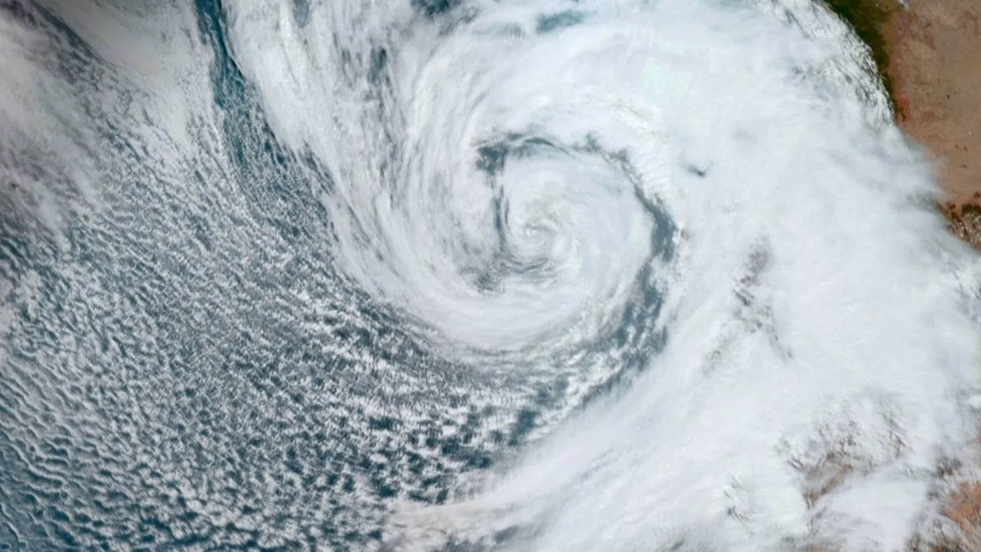
Coastal Hazards Facing Southwestern Mexico
Although Hurricane Polo began drifting northwestward parallel to the coastline rather than striking head-on, coastal communities in southwestern Mexico face significant danger from peripheral weather bands. Courtney Sargent reported for BBC News. Sargent explained that the slow-moving Pacific hurricane was projected to bring intense wind and heavy rain toward southwestern Mexico despite staying offshore [2].
The National Hurricane Center downgraded Polo to a Category 4 storm on Wednesday, September 23, but emphasized that it remains ‘a very powerful major hurricane’. The NHC issued urgent coastal advisories. Forecasters warned that torrential rainfall across the mountainous terrain of southwestern Mexico could produce life-threatening flash flooding and destructive mudslides. Steep coastal topography cannot absorb sudden tropical deluges without destabilizing saturated soil layers, creating serious risks for vulnerable settlements located along river valleys and mountain ravines [1].
In addition to inland rainfall hazards, maritime conditions along the southwest coast of Mexico remain treacherous as large swells radiate outward from the storm’s powerful core. The National Hurricane Center cautioned that dangerous surf and life-threatening rip currents will impact coastal shores for several consecutive days. Landfall in Mexico remains unexpected. Nevertheless, outer rainbands continue sweeping across coastal territories as Polo proceeds slowly along its offshore path [1].
Pacific Hurricane Polo and Global Climate Trends
The trajectory and ultimate fate of Pacific Hurricane Polo carry broader implications for weather across western North America as the cyclone continues its trek over open waters. Julian Heming emphasized that long-term forecasting models exhibit notable divergence regarding the cyclone’s future course. ‘There is currently a lot of uncertainty in the long term as to whether Polo will move further out to sea or turn north-eastwards towards Mexico,’ Heming explained [1]. Atmospheric researchers continue tracking the storm’s steering currents to determine whether it will bend back toward the mainland.
If steering currents guide the tropical system northward, Southern California could experience intense rainfall accompanied by hazardous rip currents and elevated coastal swells. As the super El Niño pattern extends into 2027, meteorologists forecast that extreme marine heat will continue priming Pacific waters for sudden cyclone escalation. The rapid transformation of Hurricane Polo provides an illustrative case study in how elevated sea surface temperatures compress cyclone development windows, demonstrating the growing potential for intense storms across warming ocean basins [1].
- ONLINE NEWS Smith, L. (2026, September 23). How did Hurricane Polo get so powerful? Live Science. [Article Link]
- ONLINE NEWS Sargent, C. (2026, September 23). Did El Niño turn Hurricane Polo into the most powerful storm of the season? BBC News. [Article Link]
APA 7: TWs Editor. (2026, September 24). Super El Niño Fuels Hurricane Polo into a Category 5 Storm. PerEXP Teamworks.


2 comments