





When explosive wildfires erupt across parched landscapes, they do more than burn vegetation; they can generate their own towering thunderstorms known as pyrocumulonimbus clouds (often abbreviated as pyroCbs). Can a terrestrial blaze truly dictate weather patterns miles above the ground? Satellite records have tracked these fire-induced columns injecting massive plumes of soot and gas directly into the stratosphere, mimicking the atmospheric disturbances of major volcanic eruptions [1].
What Are Pyrocumulonimbus Clouds?
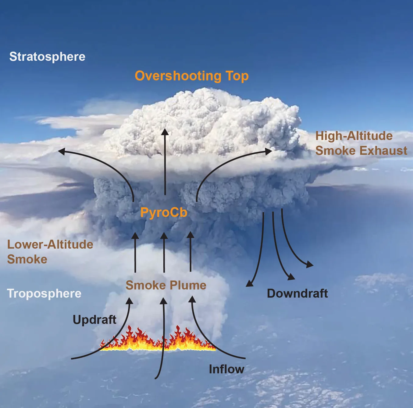
Pyrocumulonimbus clouds are extreme, fire-triggered thunderstorms that form when intense heat and buoyant smoke from a massive wildfire force air rapidly upward into the cooler troposphere (atmospheric columns driven by intense wildfire heat). As this rising column ascends, water vapor condenses around abundant smoke particles, forming dense convective storm clouds capable of generating localized lightning, hail, and erratic surface gales [1]. Atmospheric scientists categorize these structures among the most extreme manifestations of wildfire-driven weather in North America.
At the University of Nevada, Reno, atmospheric scientist Neil Lareau leads observational research into how these violent systems organize above burning terrain. “A unique thing about pyrocumulonimbus is they are fire-generated weather, meaning the fire makes its own weather,” Lareau explained while tracking active fire systems across the western states [1]. “The fire is making its own thunderstorm, and in the process of doing that, it’s also making its own wind.” Dangerous downdrafts from these formations frequently threaten ground crews by driving flames in unpredictable directions.
While earlier climate studies documented how marine bacteria and atmospheric rivers help create ice clouds through biological aerosol seeding, wildfire-generated storms rely instead on intense thermal updrafts loaded with carbon particles. These buoyant convective columns can funnel smoke between 30,000 and 50,000 feet, roughly 10 to 15 kilometers above Earth’s surface [1]. Plumes climbed 15 kilometers.

How INSPYRE Hunts Fire Clouds Across North America
NASA launched the INSPYRE campaign—short for the INjected Smoke and PYRocumulonimbus Experiment—specifically to track and measure these towering formations across western North America during the summer of 2026. Heading the airborne science effort from Southern California, principal investigator Olga Kalashnikova of the Jet Propulsion Laboratory emphasized the fundamental gaps in existing wildfire dynamics [1]. “We still do not understand if they’re driven by fire energetics, or fire intensity, or by atmospheric conditions above,” Kalashnikova noted prior to deployment.
In a hangar in Broomfield, Colorado, flight engineers prepared an NSF/NCAR Gulfstream V jet plane for six weeks of intensive aerial sampling operations. Teresa Campos, an atmospheric chemist at the National Center for Atmospheric Research in Boulder, Colorado, described the mounting urgency surrounding extreme fire behavior across the region. “We’re seeing these intense fires and unpredictable behaviours,” Campos said as crews mounted intake probes along the fuselage [3]. “It definitely feels like an important topic to be researching.”
Historically, scientists had collected only one sample of fresh smoke within the stratosphere directly above an active fire cloud. Most historical measurements relied on opportunistic research planes conducting brief sniff tests while flying unrelated atmospheric observation routes. Dave Peterson, a meteorologist with the Naval Research Laboratory and co-principal investigator on INSPYRE, highlighted the ambitious scope of the new campaign. “This time, it’s going to be more than a sniff,” Peterson said [3]. Peterson tracked 2026 fire targets.
How Do PyroCb Clouds Reach the Stratosphere?
PyroCb clouds push smoke into the stratosphere through extreme thermal buoyancy that acts like a colossal thermal chimney, propelling convective updrafts straight through the tropopause (the boundary dividing the turbulent troposphere from the stratosphere). Because intense blazes generate immense heat over concentrated terrain, buoyant updraft speeds easily overcome the stable atmospheric layers that typically keep ordinary cumulus clouds confined below [1]. Once smoke enters this dry upper atmosphere, the absence of precipitation allows fine carbon aerosols to linger and spread across entire continents.
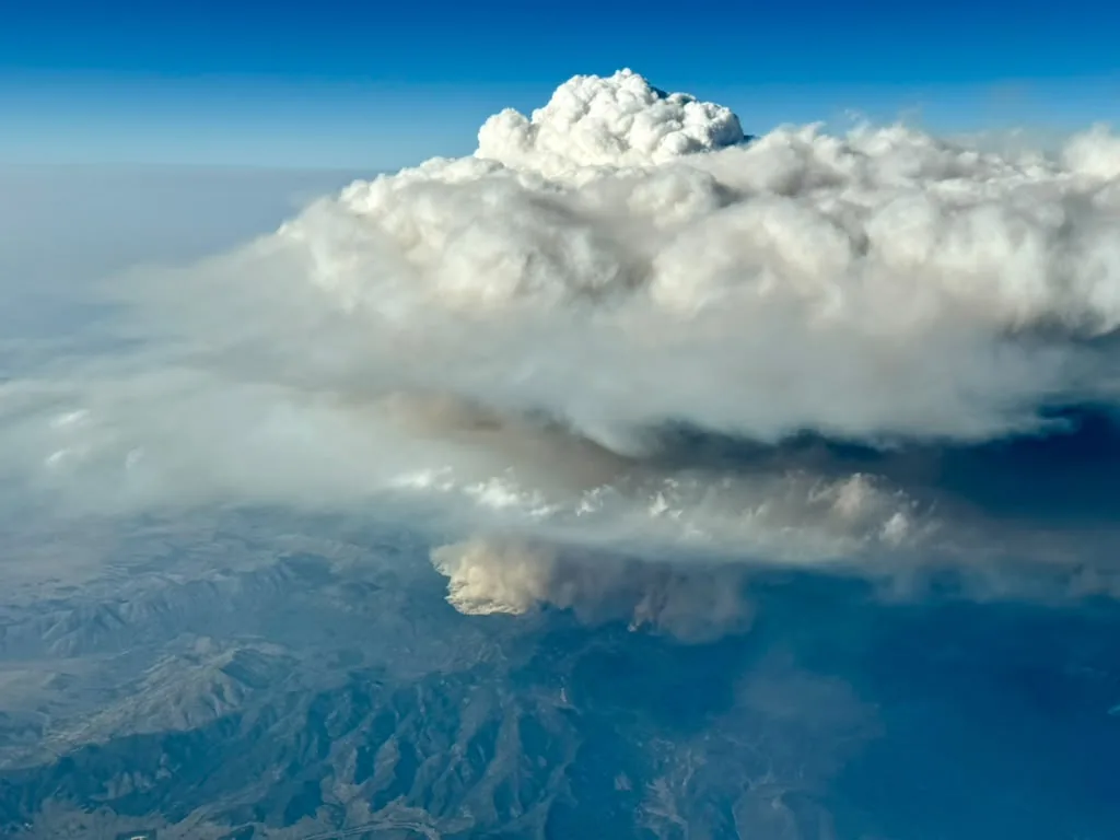
On Aug. 3, 2026, the Gulfstream V aircraft intercepted an active plume when Utah’s Widemouth 2 wildfire flared aggressively. The research jet flew directly through a high-altitude smoke corridor over New Mexico, collecting continuous particulate samples at roughly 12 kilometers (8 miles) above ground level. Satellite instruments tracked the towering formation from orbit, prompting the NASA Earth Observatory to feature the event as its Image of the Day on Aug. 17, 2026 [2].
Field teams encountered an even larger target on Aug. 26 when the Wildhorse grass fire erupted unexpectedly in eastern Idaho. The blaze initially received little priority from fire managers because grass fires rarely produce monumental convective columns. “We knew there was a grass fire there, and everyone’s like, it’s just a grass fire; we’re not going to worry about it,” Peterson recalled [1]. “And it ended up being the main event.” The Wildhorse fire erupted suddenly.

Airborne Instruments Inside Wildfire Smoke Plumes
While returning toward base from another fire zone farther west, spotter Sarah Woods of the National Center for Atmospheric Research observed the fresh remains of the Idaho plume from the jump seat. “It looks just like a big thunderstorm, and so as you approach it, you look for a visual indication of the fire on the ground,” Woods explained [1]. Seeing the scorched ground far below confirmed that the cloud was fire-generated, prompting the flight crew to swing the aircraft around and pursue the plume toward Wyoming.
For three hours, the pilots flew back and forth through the cloud and its drifting smoke trail, executing real-time chemical sampling roughly sixty minutes after the initial eruption occurred [1]. The plane (a specialized Gulfstream V research aircraft) logged radiation fluxes, photographed ice crystals, and collected aerosol concentrations across multiple cloud layers. Similar airborne transects illustrate how NASA research flights track agricultural emissions across regional air basins, demonstrating how specialized aircraft map complex atmospheric chemistry.
Meanwhile, NASA’s high-flying ER-2 aircraft supported the campaign by observing smoke plumes from high above the convective activity. Operating near the threshold of the stratosphere, the ER-2 carried 14 specialized instruments to monitor fire intensity, vertical updraft velocities, and cloud microphysics [1]. The ER-2 carried 14 instruments.
Ground Observations and Firefighter Warning Systems
On the ground, mobile instrument trucks operated by university crews navigated perimeter roads to scan fire plumes with remote-sensing systems [1]. In an overview published in Nature, science journalists Alexandra Witze and James Dinneen highlighted how multi-platform campaigns bridge aircraft observations with surface weather stations [4]. By pairing low-level inflow data with high-altitude aerial transects, researchers mapped the entire circulation structure of fire-generated storm systems.
Operational meteorologists and fire managers expect these observations to directly improve safety guidelines along wildfire perimeters. When pyrocumulonimbus clouds form, rapid cloud dynamics can suddenly whip flames into an erratic fury or generate severe downdrafts that shift surface winds without warning [1]. Lareau hopes the findings will establish an early warning framework comparable to severe thunderstorm alerts, giving fire personnel thirty to sixty minutes of notice to retreat from dangerous positions before violent downdrafts hit.
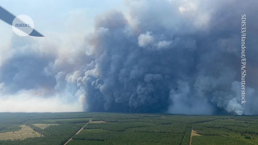
Ground crews monitored Wildhorse blazes. Sudden wind reversals driven by collapsing convective plumes remain a primary hazard for front-line wildfire personnel across western North America [1].
Climate Simulations and Long-Term Stratospheric Impacts
Beyond direct safety threats on the ground, high-altitude smoke injections present major puzzles for global climate modeling and atmospheric physics. Standard numerical prediction models do not explicitly simulate the radiative or chemical impacts of pyrocumulonimbus clouds, even though superheated updrafts loft immense tonnages of dark aerosols across the tropopause where they persist for months or years. Once established in the stratosphere, these fine carbon particles absorb solar energy, warm surrounding atmospheric layers, and reduce the amount of sunlight reaching Earth’s surface. Kalashnikova emphasized that cloud formation fundamentally alters smoke chemistry, modifying aerosol optical properties and complicating simulations of regional radiative forcing across global weather systems [1].
Integrating airborne, satellite, and ground datasets collected throughout 2026 will allow climate scientists to calibrate next-generation Earth system simulations [1]. As prolonged droughts and higher temperatures drive explosive wildfire seasons across North America and Europe, pyrocumulonimbus clouds are becoming recognized as regular stratospheric contributors rather than rare curiosities. Converting active firestorm plumes into flying laboratories allows researchers to document the precise physical lifecycles of these intense meteorological events.
Teams flew through 2026 plumes. Investigators at PerEXP Teamworks will monitor future flight deployments as airborne science teams translate high-altitude sampling records into resilient forecast models.
- PRESS RELEASE Riordon, J. (2026, October 2). NASA campaign explores clouds spawned by wildfires. NASA Science. [Article Link]
- ONLINE NEWS NASA Airborne Science Program. (2026, August 17). NASA captures giant “fire clouds” over Utah: What are pyrocumulonimbus clouds? Airborne Science Program. [Article Link]
- ONLINE NEWS NASA Airborne Science Program. (2026, August 17). First mission to fly through monstrous ‘fire clouds’ is about to take off. Airborne Science Program. [Article Link]
- ACADEMIC JOURNAL Dinneen, J., & Witze, A. (2026, July 28). First mission to fly through monstrous ‘fire clouds’ is about to take off. Nature. [Article Link]
APA 7: PerEXP Teamworks. (2026, October 3). Why Wildfire Pyrocumulonimbus Clouds Reach the Stratosphere. PerEXP Teamworks.


