





Can new orbital sensors prevent catastrophic aviation encounters with volcanic debris? When the Indonesian volcano Anak Krakatau erupted in September, the EarthCARE volcanic plume observations provided critical vertical profiles of hazardous particulates drifting across busy flight corridors [1]. Co-developed by the European Space Agency and JAXA to investigate cloud radiative physics, the satellite unexpectedly delivered near-real-time atmospheric intelligence to aviation forecasters. The orbital mission verified that hazardous aerosols had reached cruising altitudes within hours [2].
Why Did Anak Krakatau Threaten Regional Aviation?
Volcanic ash presents an immediate threat to commercial aviation because airborne silicate particles melt inside high-temperature jet turbines to form vitrified glass coatings that cause engine failure. When Anak Krakatau erupted on September 4 in the Sunda Strait between Sumatra and Java, air traffic controllers faced an immediate safety crisis. Sharp ash shards scratch cockpit windows. Phys.org reporting by scientific editor Sadie Harley and senior editor Robert Egan noted that toxic sulfur dioxide further contaminates cabin air supplies [1].
Regional disruption escalated rapidly across Indonesian airspace. The sudden explosive activity grounded thousands of flights and stranded hundreds of thousands of passengers throughout Indonesia and neighboring transit hubs. While initial geological reporting in Anak Krakatau Eruption: What the Ash Reveals centered on ground-level tephra and caldera geology, this analysis evaluates orbital sensor synergy that actively slices the plume vertically to secure civil flight corridors. Anak Krakatau means Child of Krakatoa. To mitigate these perils, a global network of nine Volcanic Ash Advisory Centers (VAAC) provides aviation guidance across designated planetary sectors [1].
Turbines face catastrophic failure from glassification. Monitoring dynamic ash clouds requires rapid coordination between meteorological agencies and international air carriers. The Darwin VAAC, operated by the Australian Bureau of Meteorology (BOM), assumed responsibility for tracking the plume drifting from Anak Krakatau across busy air routes [1]. Aviation regulators urgently required precise vertical altitude data from the EarthCARE volcanic plume observations before establishing exclusion zones [2].
How EarthCARE Volcanic Plume Data Tracks Ash
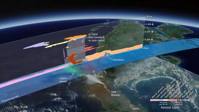
Orbital tracking changed significantly when scientists directed the EarthCARE volcanic plume observation suite toward the Sunda Strait to analyze the eruption column. Co-engineered with JAXA, the satellite carries four specialized instruments designed to operate in close synergy: the atmospheric lidar known as ATLID, the cloud profiling radar known as CPR, the multispectral imager or MSI, and the broadband radiometer designated as BBR [2]. ATLID operates at 355 nanometers [3]. Through these ultraviolet backscatter measurements, ATLID constructs detailed vertical curtains that reveal aerosol layers from cloud tops down toward the sea surface [1].
The EarthCARE volcanic plume observations enabled atmospheric researchers to estimate specific aerosol classifications using advanced computational inversion algorithms [1]. Developed by Donovan and colleagues, the A-PRO profile processor evaluates depolarization and backscatter ratios so ATLID differentiates fine ash particles, industrial smoke, marine sea salt, desert dust, and sulfate droplets within complex airborne plumes [4]. Optical sensors mistaking reflective clouds for ash trigger disruptive airspace closures [2].
EarthCARE delivered unprecedented vertical cross-sections across the Indonesian eruption plume. These lidar curtains showed that the eruption column did not disperse as a uniform cloud but separated into stratified aerosol ribbons with distinct physical densities [2]. While low-altitude ash drifted near the caldera, lighter aerosol fractions climbed rapidly into upper atmospheric boundaries. Darwin VAAC forecasters incorporated these profiling streams to evaluate where ash presented acute aviation hazards [1].
How CPR Advances Volcanic Plume Measurements
Radar detection provides a crucial complementary perspective because microwave pulses interact differently with atmospheric matter than optical lasers. While ATLID relies on ultraviolet wavelengths to detect fine particles and aerosol boundaries, the Cloud Profiling Radar operates at longer wavelengths that exhibit heightened sensitivity to larger particulates. Robin Hogan, an atmospheric scientist from the European Center for Medium-Range Weather Forecasts (ECMWF), highlighted this divergence. Hogan explained that scientists normally expect volcanic particles 200 km (124 miles) downwind from the vent to be far too small for radar detection [1].
The unprecedented sensitivity of CPR revealed unexpected features within the plume. Despite the substantial distance from the erupting vent, the radar detected a prominent feature extending from the ocean surface up to approximately 6 km (3.7 miles) in altitude. The radar curtain reached 6 km. Hogan noted that this dark brown signature in the processed radar curtains corresponds to larger ash aggregates settling out of the drifting plume. As fine suspended particles collide and clump together within the turbulent volcanic atmosphere, their combined mass causes them to descend rapidly toward the ocean surface [1].
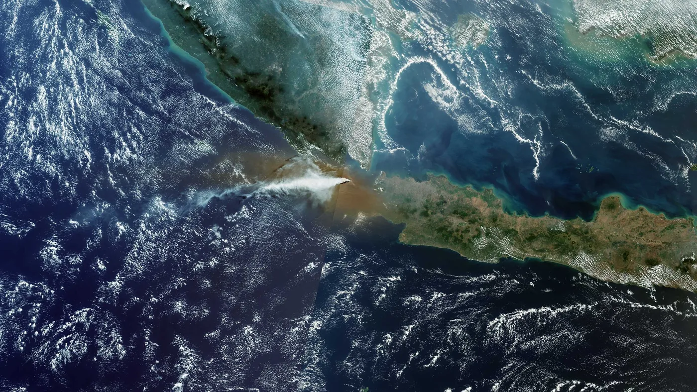
Radar echoes revealed coarse particle precipitation. These detailed volcanic plume measurements provide direct empirical tracking of ash precipitation dynamics that ground observers cannot observe through overcast skies [2]. Analyzing the EarthCARE volcanic plume structure revealed how different instruments resolve distinct particulate scales across the atmosphere [1].


Can Radar Differentiate Falling Ash Aggregates?
Radar detects falling ash aggregates directly by capturing reflected microwave energy from coarse particles that optical lidar beams cannot distinguish within dense cloud layers [1].
Helen Dacre, an atmospheric scientist at the University of Reading in the UK, emphasized the wider significance of these radar observations for dispersion modeling. Dacre pointed out that if confirmed, this detection provides valuable empirical evidence demonstrating that large ash particles can remain aloft for longer durations and travel farther from the volcanic vent than atmospheric dispersion models generally assume. Observing these coarse aggregates 200 kilometers downwind from the volcanic vent offers an invaluable opportunity to constrain ash sedimentation rates and calibrate long-range particulate transport equations [1].
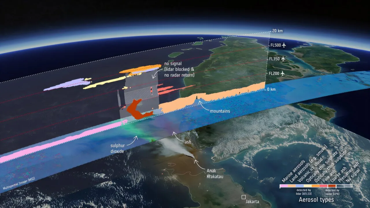
Atmospheric dispersion modeling benefits from these observations. Sensor synergy also exposed critical observational blind spots within the EarthCARE volcanic plume profile. Satellite imagery revealed a distinct grey region where ATLID’s ultraviolet beam suffered total attenuation beneath an optically thick layer of orange sulfate particles aloft. Meanwhile, CPR lacked sufficient sensitivity to capture fine ash suspended inside that specific zone [2]. For commercial airlines, this ambiguous region carried an unequivocal advisory from aviation meteorologists: civil aircraft must not fly through this airspace [1].
Why Volcanic Aerosol Tracking Protects Flight Corridors
Flight safety depends upon establishing precise vertical boundaries because jetliners cannot safely navigate across airspace contaminated by abrasive volcanic materials. Most commercial aircraft cruise at flight level FL350, corresponding to an altitude of 35,000 feet or roughly 10,700 meters. Cruising jets navigate around FL350. When Anak Krakatau propelled ash into regional flight paths, aviation controllers needed to determine whether dangerous aerosols hovered near cruising ceilings or remained confined to lower maritime layers. Multispectral data from Copernicus Sentinel-3 captured the plume spreading westward across the Sunda Strait on Sept. 5, showing purple signatures for ash and green bands indicating sulfur dioxide gas [2].
Andy Prata of the Australian Bureau of Meteorology explained that forecasters integrated ATLID measurements directly into their operational tracking workflows. Working in coordination with Darwin VAAC specialists, Prata verified that the upper-level component of the westward-moving plume climbed to flight level FL500, reaching an altitude of approximately 15 km (9.3 miles). The plume topped FL500 at 15 km. Reliable volcanic aerosol tracking at FL500 prevented airliners from inadvertently ascending into dense particulate streams. Constraining the EarthCARE volcanic plume dynamics helped researchers refine predictive transport models and establish safe flight rerouting corridors [1].

Shannon Mason, an atmospheric researcher at ECMWF, underscored the volatile nature of volcanic plumes during active eruptions. Atmospheric analyst Imran Mahmood noted that EarthCARE swept past Anak Krakatau on the afternoon of Sept. 5, roughly 30 minutes after VIIRS recorded the advancing cloud. Mason explained that volcanic events generate complex, rapidly evolving atmospheric mixtures where discrete layers of ash, meteorological clouds, sulfurous gases, and secondary aerosols continuously interact [1]. Grasping this vertical structure in near-real time allowed forecasters to furnish airlines with accurate, hour-by-hour flight guidance rather than blanket airspace shutdowns [2].
Tracking Atmospheric Injection and Long-Term Climate Impacts
Analyzing the EarthCARE volcanic plume confirmed how explosive eruptions inject sulfur dioxide into the stratosphere, altering planetary climate long after immediate disruptions subside. Alex Hoffmann from the European Space Agency pointed out that historical eruptions offer compelling lessons regarding atmospheric longevity. When the 1883 eruption of Mount Krakatoa obliterated the volcanic edifice, sulfate aerosols lingered in the stratosphere for over a year, scattering sunlight and inducing temporary global cooling. Sulfate aerosols persisted over a year [1]. Understanding the exact injection altitude of volcanic effluents remains vital for calculating how much radiant energy reflects back into space [2].
ATLID provides an ideal tool for measuring these optical properties and monitoring long-range aerosol transport across planetary scales [1]. Detailed in Atmospheric Chemistry and Physics by Sergey Khaykin and colleagues, ATLID demonstrated this capability by mapping stratospheric aerosols following the 2024 eruption of Mount Ruang in Indonesia. Khaykin’s research team verified that ATLID’s 355 nm ultraviolet laser resolves vertical aerosol structures at 100-meter resolution up to 20 km [3]. These orbital observations provide essential boundary data that complement geophysical investigations of eruptive mechanics, much like ongoing research into magma chambers under the Hunga volcano that illuminates how magma reservoirs generate sudden explosive plumes.
The Anak Krakatau observations confirm EarthCARE’s dual role in civil protection and climate science. By operating ATLID, CPR, MSI, and BBR simultaneously, researchers obtain a unified cross-section of atmospheric dynamics that links localized aviation risks to planetary radiative balance [2]. Flight safety authorities now rely on orbital laser profiling to identify invisible ash hazards, while climatologists utilize the identical data streams to refine Earth’s complex energy budget models [1]. Satellite validation of the EarthCARE volcanic plume demonstrated how multi-instrument orbital platforms deliver the precise vertical intelligence necessary to keep commercial flight corridors safe [2].
- ONLINE NEWS Harley, S., & Egan, R. (2026, October 1). EarthCARE’s view of volcanic plume boosts air safety. Phys.org. [Article Link]
- PRESS RELEASE European Space Agency. (2026). EarthCARE’s view of volcanic plume boosts air safety. ESA. [Article Link]
- ACADEMIC JOURNAL Khaykin, S., Sicard, M., Leblanc, T., Sakai, T., Balugin, N., Berthet, G., Chevrier, S., Chouza, F., Feofilov, A., Gantois, D., Godin-Beekmann, S., Haddouche, A., Jin, Y., Morino, I., Kadygrov, N., Lecas, T., Liley, B., Querel, R., Taha, G., & Yushkov, V. (2026). Global transport of stratospheric aerosol produced by Ruang eruption from EarthCARE ATLID, limb-viewing satellites and ground-based lidar observations. Atmospheric Chemistry and Physics, 26, 607–625. [Article Link]
- ACADEMIC JOURNAL Donovan, D. P., van Zadelhoff, G., & Wang, P. (2024). The EarthCARE lidar cloud and aerosol profile processor (A-PRO): the A-AER, A-EBD, A-TC, and A-ICE products. Atmospheric Measurement Techniques, 17(17), 5301-5340. [Article Link]
APA 7: PerEXP Teamworks. (2026). EarthCARE Volcanic Plume Tracking Guards Flight Safety. PerEXP Teamworks.


