






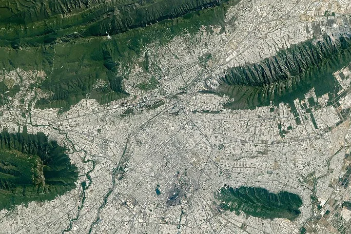
The Monterrey mountains mark the edge of a metropolis of 5.3 million people, bringing ancient rock folds into direct contact with expanding neighborhoods. NASA Earth Observatory describes this meeting of city and terrain in an astronaut photograph taken on August 26, 2026. The mountains around Monterrey include the Sierra Madre Oriental (Eastern Sierra Madre), whose parallel ridges record a history far older than the urban area. The image shows where the city meets those ridges and the river corridor running through them. [1]
Monterrey Mountains: Why the Parallel Ridges?
NASA Earth Observatory traces the ridges along Monterrey’s southern edge to limestone layers deposited during the late Mesozoic era, before deformation bent them into the structures that now distinguish this part of the Sierra Madre Oriental. Folding came later. NASA places that episode between about 80 million and 50 million years ago. Erosion then removed weaker rock layers over millions of years, leaving the ridgelines that border the city today. The curved, roughly parallel bands in the photograph reflect several stages in a long geological history: rock accumulation, folding and the gradual removal of less resistant material from the surrounding landscape. [1]
Why do the mountains look like repeated bands? NASA’s explanation links their appearance to folded layers and their differing resistance to erosion. Folding and erosion both contributed to the landscape. The photograph records the resulting forms; the geological ages come from the accompanying account, not from measuring the appearance of the image itself.
Monterrey’s limestone folds also offer a different geological subject from the Socorro magma body covered by PerEXP Teamworks. Here, NASA’s account centers on layered rock and erosion.
Where Does the City Expand?
Monterrey is the capital of Nuevo León, in northeastern Mexico. Industry anchors the city’s economy. NASA lists ironworks, steelworks and manufacturing facilities producing textiles, processed foods, glass and plastics among its activities, placing the mountainous setting around a substantial industrial center rather than an isolated settlement. The metropolitan population of 5.3 million comes from the 2020 census. It describes the wider metropolitan area, and it should not be read as a new population measurement made when the astronaut took the photograph in 2026. [1]
Researchers cited by NASA found that Monterrey’s overall population has grown since 1990 while the population living within 5 kilometers (3 miles) of its center has declined. Metropolitan growth and central population decline can occur together. NASA reports a similar trajectory in many Mexican metropolitan areas. For Monterrey, the nearby ridges add a physical constraint: urban expansion encounters steep, folded terrain along the southern margin. NASA does not identify the researchers or provide a numerical expansion rate in the supplied account, so the photograph cannot establish how quickly particular neighborhoods have grown.
Why Does a Dry River Matter?
The Río Santa Catarina cuts through the mountains and reaches the semiarid floodplain occupied by Monterrey. Water is often scarce. NASA describes the river as carrying little or no water much of the time because of the dry environment, yet its channel remains important for collecting runoff from summer rains. A low-flow channel still has a drainage role. The route through the city connects the mountain setting with the urban core, giving the river a function that a photograph taken at one moment cannot fully represent. [1]
Plants and animals also use the river corridor as a natural area within Monterrey. NASA’s description brings those ecological and drainage functions together without supplying a species inventory or a measured volume of seasonal runoff. How much water follows a particular summer storm remains outside the account. The channel’s importance is clear, but this source does not provide enough information to calculate flood probability or compare the effects of different storms.
Seasonal precipitation raises a separate mountain question in PerEXP Teamworks’ coverage of intense snowfall in the French Alps under climate change. For Monterrey, NASA discusses summer runoff without attributing a local rainfall trend to climate change.


What Lives Above the City?
Sierra Las Mitras rises approximately 1,500 meters (4,900 feet) above the city and forms one of the island-like protrusions of folded rock near the river’s route. Its protection dates to 2000. NASA identifies the ridge as a state nature reserve and describes it as a refuge for wildlife. Among the Monterrey mountains, Las Mitras provides a particularly direct example of how elevation changes the conditions available to plants, even within a landscape close to extensive urban development. [1]
Cacti and thorny shrubs occupy the lower rocky slopes, while oak and pine forests grow higher on the ridge, where NASA describes conditions as cooler and wetter. Vegetation changes with elevation. The source connects that transition to local conditions rather than presenting the whole mountain as one uniform habitat. NASA’s account does not name individual wildlife species or measure their populations, so the reserve’s ecological role should remain distinct from claims about whether particular species are increasing or declining.
NASA also identifies Cerro de la Silla, or Saddle Hill, as a prominent landmark among the Monterrey mountains. [1]
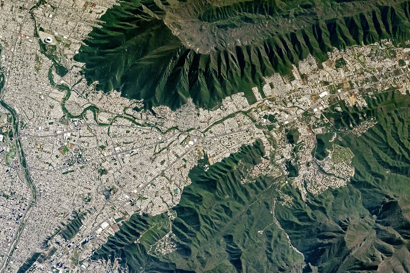
NASA’s earlier Mount Silla and Monterrey account explains the name: from the west, the mountain’s peaks and ridges resemble a saddle. Andi Hollier describes forested slopes above the metropolitan area in the photograph taken on February 17, 2017. The account follows the Santa Catarina through older neighborhoods and describes rivers that remain dry for much of the year, providing an earlier geographical reference for NASA’s 2026 description. [2]
How Did NASA Capture the View?
An Expedition 75 crew member aboard the International Space Station took photograph ISS075-E-70481 on August 26, 2026, using a Nikon Z9 digital camera with a 400-millimeter focal length. NASA does not name the astronaut. The ISS Crew Earth Observations Facility and the Earth Science and Remote Sensing Unit at NASA Johnson Space Center provided the image. NASA’s processing included cropping, contrast enhancement and removal of lens artifacts; the published view is a prepared version of the photograph rather than an untouched camera file. [1]
NASA’s Monterrey Amid Mountains account credits Lindsey Doermann for the story. The International Space Station Program supports crew photography through the ISS National Lab, helping astronauts obtain Earth images useful to scientists and the public and making them freely available online. The image documents a landscape at one moment. It supplies spatial context for the Monterrey mountains, but the population figures, geological chronology and ecological descriptions depend on the information NASA presents with it.
What Connects Monterrey With Space Apps?
Universidad de Monterrey sits near the city’s border with the Sierra Madre Oriental. NASA identifies the university as a host venue for the NASA Space Apps Challenge, an annual hackathon that its September 11 account schedules for November 2026. Teams use NASA and partner-agency data to address challenges in software development, astrophysics, space exploration and agriculture. Participation spans physical venues and virtual settings around the world. The university’s location gives the photograph a local connection to that broader use of space-agency data. [1]
NASA directs readers to the NASA/JSC Gateway to Astronaut Photography of Earth for additional photographs by astronauts and cosmonauts. The 2026 view carries identifier ISS075-E-70481. The earlier Mount Silla image carries ISS050-E-51179 and comes from Expedition 50, whose crew used a Nikon D4 camera with an 1150-millimeter lens. [1, 2] Comparing change in the Monterrey mountains would require photographs with comparable coverage and viewing conditions; these two published accounts do not supply a measured time series of urban expansion.
- WEBSITE Doermann, L. (2026, September 11). Monterrey amid mountains. NASA Earth Observatory. [Article Link]
- WEBSITE Hollier, A. (2017, May 10). Mount Silla and Monterrey. NASA Earth Observatory. [Article Link]
APA 7: TWs Editor. (2026, September 11). Ancient folds frame Monterrey mountains in NASA’s new view. PerEXP Teamworks.


1 comment