





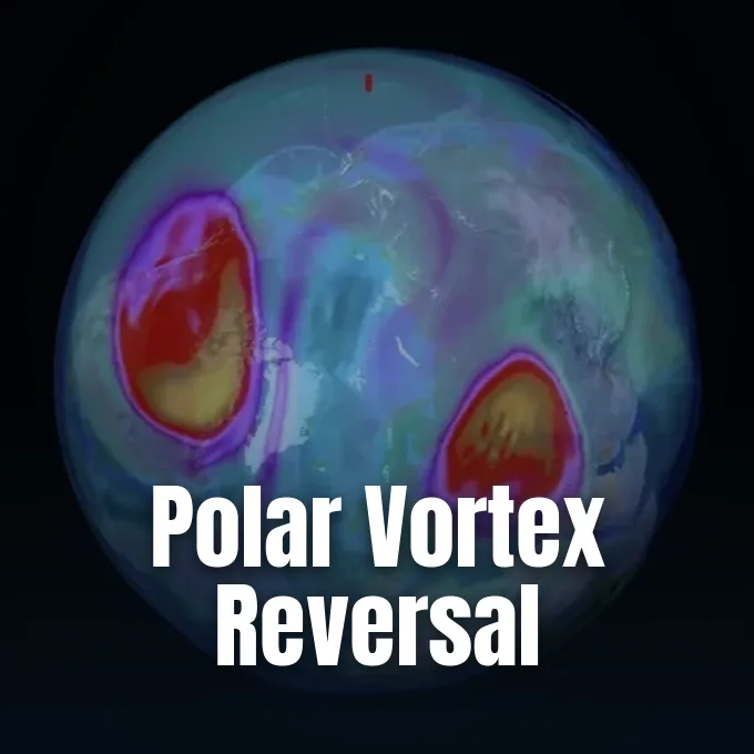
On November 10, 2026, atmospheric scientists tracked a collapse in Arctic stratospheric circulation as high-altitude westerly winds reversed direction weeks earlier than ever recorded. The sudden polar vortex breakdown disrupted the ring of winds that normally bottles cold air over the pole during autumn [1]. While collapses in this circulation happen every few years, weather balloon observations dating back to the 1950s have never captured a full reversal this early in autumn [2]. As meteorologists examine whether a record super El Niño drove the event, conflicting atmospheric signals suggest regional pressure ridges over Europe also contributed [1].
Record November Polar Vortex Breakdown
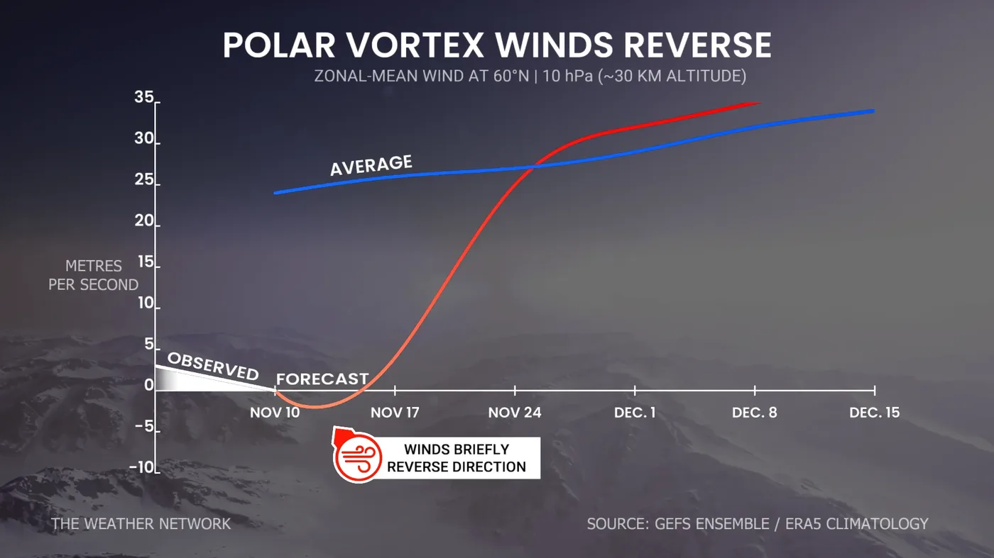
Measurements from meteorological agencies revealed that stratospheric winds high above the Arctic ground to a halt before turning eastward. According to data tracked by Tyler Hamilton at The Weather Network, circumpolar wind speeds dropped from typical speeds of 25 meters per second to minus 0.1 meters per second on November 10. Speeds dropped to minus 0.1 meters per second. This shift occurred roughly 30 kilometers above the surface, marking the first time in recorded observation that a full collapse happened so early in autumn [6].
Previous early disruptions recorded in 1958, 1968, and 2025 all took place on November 28, meaning the 2026 collapse arrived 18 days earlier than any prior benchmark [1]. Previous record disruptions all occurred on November 28. Tim Stockdale and Frederic Vitart, principal scientists at the European Centre for Medium-Range Weather Forecasts (ECMWF), confirmed the event to reporters. “As far as we know, this is the earliest stratospheric vortex disruption that has been observed,” Stockdale and Vitart said [2].
Analysis from the FOX Forecast Center noted that the polar vortex normally circles the Arctic from roughly 55 degrees north latitude, keeping frigid air contained while strengthening gradually through December. Winds typically blow at 25 meters per second. When westerly winds reverse, that protective containment weakens, opening pathways for Arctic air masses to spill southward into mid-latitude regions [7].
How Atmospheric Waves Rise From the Pacific
Meteorologists seeking causes for the disruption focused on the equatorial Pacific Ocean, where an intense climate pattern continues to develop. Scientists tracking equatorial sea surface temperatures through NASA satellite observations of the 2026 El Niño recorded warm water shifting eastward across the Pacific basin as trade winds weakened. As east-to-west trade winds weaken, rising warm air creates an expansive low-pressure center that alters global wind patterns, triggering a polar vortex breakdown. Adam Scaife, head of long-range prediction at the UK Met Office, explained that this shift introduces waviness into the tropospheric jet stream, deepening the Aleutian low near Alaska [1].
These planetary ripples, known to meteorologists as Rossby waves, do not merely travel horizontally along the jet stream. They can also propagate upward into the stratosphere, growing in amplitude as air density drops with altitude. When these waves crash into the circumpolar vortex, they deposit easterly momentum against the prevailing westerly flow. “When they dump that momentum, they push the polar vortex against its flow, and they weaken it,” Scaife said. While Scaife suspects that Pacific warmth sped up the disruption, he cautioned that an absolute causal connection remains unproven because early winter El Niño conditions typically bolster polar circulation [1].
The Scandinavian Blocking Ridge
Not all atmospheric scientists agree that equatorial ocean temperatures served as the main trigger for the stratospheric collapse. Andrew Charlton-Perez, a professor of meteorology at the University of Reading (UK), pointed instead to a strong high-pressure blocking pattern that settled over northern Europe. “I would be wary of saying it was caused by El Niño,” Charlton-Perez said, adding that “the blocking high is probably more important” in destabilizing the upper atmosphere. This persistent ridge over Scandinavia and northwestern Russia forced jet stream winds into sharp loops, generating wave energy that surged vertically into the polar stratosphere without requiring Pacific assistance [1].
Climatologist Judah Cohen from the Massachusetts Institute of Technology observed that high-pressure blocking patterns over Scandinavia typically develop during La Niña events rather than during strong El Niño seasons. Cohen noted that changing conditions across Eurasia might also play a role in generating these blocking systems. Melting sea ice around Scandinavia has warmed local waters, but expanding autumn snow cover across East Asia has chilled the continental interior. This sharp temperature contrast across Eurasia can reinforce wave activity, driving atmospheric energy straight into the polar stratosphere and weakening westerly winds [2].


Surface Cold Snaps and Delayed Effects
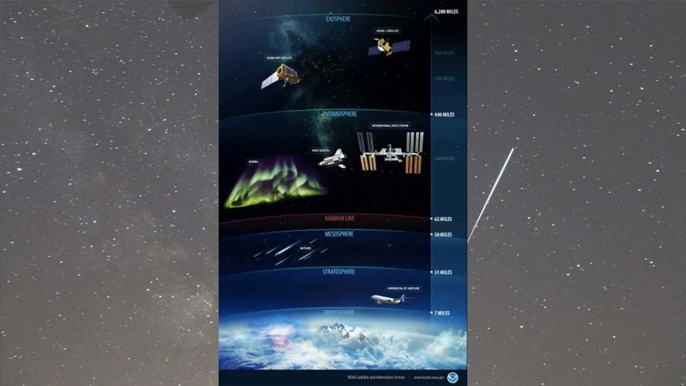
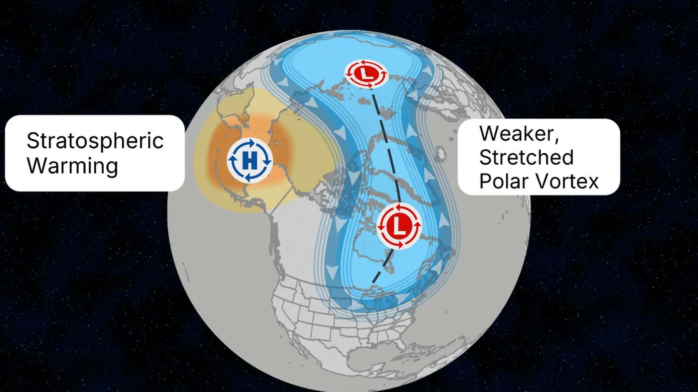
The sudden collapse of stratospheric winds produces a phenomenon known as a sudden stratospheric warming event. When circulating winds slow or reverse, air over the North Pole rapidly compresses and sinks, causing stratospheric temperatures to rise between 50 and 70 degrees within days [3]. Jonathan Erdman, senior meteorologist at The Weather Channel, compared the temperature rise to the heat generated when pumping air into a bicycle tire. Although this warming unfolds more than six miles above the ground, the resulting circulation anomaly can gradually descend into the troposphere over several weeks, shifting the jet stream and allowing Arctic air to migrate southward [5].
Despite the disruption in the stratosphere, cold air does not reach populated surface areas overnight. Grahame Madge, a spokesperson for the UK Met Office, pointed out that Arctic surface air masses in early November have not yet accumulated mid-winter cold. Because reservoir temperatures over Siberia and northern Canada remain relatively moderate at this point in autumn, initial cold outbreaks escaping the polar cap may prove less severe than mid-winter freezes [2]. The 2018 freeze killed 10 people in Britain.
In 2018, a mid-winter breakdown contributed to the deadly Beast from the East snowstorms in Europe, demonstrating how stratospheric shifts can reshape surface weather [1]. Forecasters at Météo-France emphasized that surface impacts from the current event depend heavily on how wind anomalies propagate downward [2]. If the displaced vortex sets up a Greenland blocking pattern, it could draw persistent cold air into the eastern United States and western Europe by late November [5].
Winter Polar Vortex Disruption Facing Strong El Niño
Any cold air unleashed by the polar vortex disruption faces direct opposition from the powerful El Niño dominating the lower atmosphere. Earlier seasonal outlooks had already highlighted widespread atmospheric impacts, including how the Met Office warned record El Niño conditions raise autumn flood risks across western Europe. In North America, the energized Pacific jet stream continues pumping mild marine air across Canada and the northern United States [6, 7]. Joshua Senechal, senior meteorologist with The Weather Company energy forecast team, stated that blocking patterns will struggle to overpower the strong warming influence of the Pacific system [5].
Can a strong El Niño completely shield mid-latitude regions from an Arctic freeze? When tropical heating expanded across oceanic basins earlier in the year, as documented when Super El Niño fueled Hurricane Polo into a Category 5 storm, meteorologists noted how persistent Pacific warmth resists high-latitude cooling patterns. Michael Shuman, also a senior meteorologist with The Weather Company, noted that the Northern Hemisphere is simply not in prime winter mode to sustain prolonged cold snaps [5].
This opposition sets up what forecasters describe as an atmospheric tug-of-war between competing global climate forces. Senechal noted that the orientation of the stratospheric warming favors early impacts in Europe rather than North America, though the eastern United States could see brief cool periods [5]. Cohen summarized the clash by noting that scientists have never observed a major polar vortex disruption alongside an intense super El Niño, creating an uncharted forecasting puzzle. “So in some ways, this is uncharted territory,” Cohen said [3].
Forecast Uncertainties for December
Meteorological models indicate that the wind reversal itself will be relatively brief, with stratospheric speeds expected to recover toward normal westerly values by late November. Tyler Hamilton noted that wind speeds are projected to climb back past 25 meters per second, but emphasized that atmospheric ripple effects often persist for weeks after the vortex recovers. Canada released its winter outlook on November 25. European ensemble guidance suggests that circulation over the northeast Pacific might transition into a negative Eastern Pacific Oscillation phase during the final days of November. If ridging develops over Alaska, it could carve a trough across North America, finally tapping Arctic air pools [6].
Long-range outlooks from the Climate Prediction Center (CPC) still favor above-average temperatures across the northern United States through December, including the Upper Midwest, Northern Plains, and Pacific Northwest [7]. While forecasters at Atmospheric G2 led by Todd Crawford predict one of the warmest early winters on record for the United States, Crawford noted that models hint at another potential polar vortex breakdown later in January or February [5]. With unusual warmth still lingering across Northern Canada, whether Arctic chill breaks into mid-latitudes will depend on which global climate driver maintains control of the hemispheric jet stream [6].
- ONLINE NEWS Luhn, A. (2026). Did El Niño cause an early breakdown in the polar vortex? New Scientist. [Article Link]
- ONLINE NEWS Ahmed, I., & Thomet, L. (2026). Polar vortex faltering weeks earlier than ever recorded. Phys.org. [Article Link]
- ONLINE NEWS Shah, S. (2026). What An Early Polar Vortex Combined With El Niño Means For Winter Weather. TIME. [Article Link]
- ONLINE NEWS Karlík, T. (2026). Polar vortex weakening, according to data. RTÉ News. [Article Link]
- ONLINE NEWS Erdman, J. (2026). Polar vortex will be weird soon. What super El Niño says about it. The Weather Channel. [Article Link]
- ONLINE NEWS Hamilton, T. (2026). The polar vortex just made a historic reversal. What now, Canada? The Weather Network. [Article Link]
- ONLINE NEWS Sullivan, K., & Atienza, J. (2026). Polar Vortex disrupted at the earliest point in a calendar year on record — what happens next? FOX Weather. [Article Link]
- ONLINE NEWS Luhn, A. (2026). Polar vortex suffers earliest recorded breakdown. New Scientist. [Article Link]
APA 7: PerEXP Teamworks. (2026, November 14). Arctic Winds Reverse in Early Polar Vortex Breakdown. PerEXP Teamworks. https://perexpteamworks.com/en/polar-vortex-breakdown-el-nino-debate/


