






Can an early autumn storm produce the destructive surge typically reserved for mid-winter blizzards? A powerful nor’easter storm battered the Mid-Atlantic and northeastern coastlines this weekend, funneling gale-force winds and oceanic water into vulnerable shorelines without dropping a single flake of snow. Tens of millions of residents from Virginia to Maine faced coastal inundation as governors Kathy Hochul of New York and Mikie Sherrill of New Jersey declared states of emergency [1].
What Defines a Nor’easter Storm?
A nor’easter storm is defined as a macro-scale extratropical cyclone characterized by prevailing winds that blow intensely from the northeast off the Atlantic Ocean. Unlike warm-core tropical systems such as tropical cyclones fueled by ocean heat, this meteorological phenomenon is a cold-core low-pressure system that draws energy from sharp horizontal temperature gradients between cold continental air and milder ocean currents. While public perception closely links these events to freezing temperatures, blowing snow, and whiteout conditions that paralyze northeastern cities during deep winter, the fundamental meteorological classification depends entirely on cyclone structure, atmospheric dynamics, and wind orientation rather than frozen precipitation [2].
Meteorologists observed no snowfall during the late-September occurrence. Mild autumn surface temperatures maintained all precipitation strictly as heavy rain bands across coastal plains [2].
When an extratropical cyclone consolidates in early autumn, its primary danger shifts from accumulating blizzards to marine surge and shoreline erosion. The National Weather Service alerted communities that onshore gale winds would generate elevated surf, battering barrier beaches and driving seawater into estuaries. Communities from the Carolinas up to Boston braced for dangerous surf capable of tearing away dunes and washing over coastal roadways [1, 3].

What Causes a Nor’easter Storm?
A nor’easter storm forms when a strong atmospheric pressure difference develops between a stationary high-pressure system over eastern Canada and a deepening low-pressure system advancing along the southeastern United States coastline. In this event, strong easterly winds developed as air funneled directly through the narrow corridor separating a high-pressure ridge anchored to the north from a deepening coastal low positioned to the south. Meteorologists at Storm Team 4 explained that this pressure differential accelerated offshore winds, driving persistent easterly gales toward the tri-state area days before the primary center made its closest approach [2].
As the low pressure deepened over warm offshore waters, the circulating air mass organized into a massive vortex. Winds between 40 and 60 mph persisted throughout Saturday as precipitation arrived in successive waves across New York, New Jersey, and Connecticut. Atmospheric pressure gradients dictated both the intensity and duration of the gale. The storm stalled temporarily off the southern coast of Long Island, elongating the fetch—the uninterrupted distance over water where wind blows in a constant direction—which built massive ocean swells [2, 3].
Total rainfall accumulations reached upwards of 4 inches along shoreline sectors, though the meteorological progression mitigated the threat of inland catastrophe. Eric Braate noted that because the heavy rain fell over a 48-hour period rather than during a sudden torrential burst, regional soil profiles absorbed much of the volume, preventing severe urban flash flooding away from coastal rivermouths [2].
Pressure Gradients Fueling Atlantic Winds
Numerical forecast models initially anticipated that the storm center would stay well out to sea, but the low tracked much closer to the New Jersey and Long Island shorelines than early computer guidance suggested. This westward adjustment concentrated severe pressure gradients directly along the coastal interface, creating an immediate potential for sustained gale forces and wind gusts between 60 and 70 mph across eastern Long Island, New York City, and the Jersey Shore [3]. Coastal wind advisories and high wind warnings blanketed the tri-state area as atmospheric turbulence increased throughout Friday night and Saturday morning [2]. In New York, state emergency planners warned that localized wind gusts reaching 55 mph (86 km/h) would fell mature trees, splinter large branches, and tear down overhead distribution lines, jeopardizing the regional power grid across multiple counties [1].
Meteorologists highlighted a sharp divergence in atmospheric conditions between immediate maritime beaches and interior suburban zones. Inland locations experienced significantly less severe wind speeds and modest rainfall amounts, shielding inland cities from structural damage [2]. Winds reached 45 mph onshore [3].
Forecasters noted that if the eye of an extratropical cyclone tracks inland, surface friction over land rapidly disperses its rotational energy. Because the system meandered directly over coastal waters south of Long Island instead of pushing inland, the vortex maintained peak maritime intensity for over twenty-four hours [2, 3]. Offshore low-pressure centers draw moisture and momentum continuously from ocean surface heat, prolonging severe gales across the coastline [3].


Coastal Nor’easter Deluges Island and Shorelines
The arrival of the coastal nor’easter translated into destructive ocean flooding along low-lying shorelines from the Mid-Atlantic to southern New England. In New Jersey, floodwaters surged over bulkheads and seawalls on Saturday morning, inundating streets, driveways, and ground-floor residential structures in barrier island communities like Surf City and Manasquan. Surf City declared an emergency [1]. Stafford Township police closed vehicular access to Long Beach Island when rising bay tides submerged arterial roads, stranding local transport before receding waters permitted emergency access hours later [3].
Further north on Long Island, south-facing ocean beaches bore the brunt of destructive breakers. FOX Weather storm specialist Mike Seidel reported from Greenport, New York, where massive swells caused by the nor’easter storm battered waterfront houses, washing over revetments and depositing thick sheets of ocean debris across coastal avenues. In Point Pleasant, New Jersey, municipal authorities issued voluntary evacuation advisories as seawater pushed across neighborhood streets, cutting off residential blocks from primary emergency routes [3].

The US National Weather Service issued urgent instructions urging residents in flood-prone zones to take immediate action: “Prepare immediately for significant inundation in low-lying areas near the shore, including roads underwater and impacts to homes and businesses” [1]. Emergency managers emphasized that while coastal flooding peaked late Saturday morning for New Jersey, south-facing shores on Long Island faced additional rounds of widespread major inundation during Sunday high tides [2].
Astronomical High Tides Worsen Coastal Inundation
A critical meteorological amplifier occurred in the lunar calendar: Saturday’s full moon created peak astronomical spring tides, pulling ocean water higher than normal baseline levels [1]. When strong, persistent northeasterly gales coincided with these maximum astronomical tides, ocean water was driven forcefully into shallow coastal inlets. Trapped water in back bays and estuaries was unable to drain through tidal inlets during low tide, causing water levels to remain dangerously elevated throughout consecutive tidal cycles [3].
According to analysis released by the FOX Forecast Center, “these persistently strong onshore winds combined with high surf and high astronomical tides will likely result in widespread major coastal flooding through the weekend”. FOX Weather correspondent Kieran Sullivan noted that millions of coastal residents braced for the most severe tidal surges witnessed since Superstorm Sandy in 2012, highlighting how prolonged wave impacts compounded infrastructure risks. High tides compounded the surge [3].

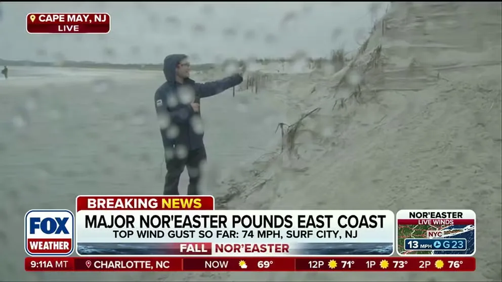
Offshore waves peaked between 15 and 18 feet from the Outer Banks of North Carolina to New Jersey, chewing away massive volumes of sand from protective coastal dunes. In Cape May, New Jersey, multimedia reporter Pete Cuddihy reported that relentless nor’easter storm surf caused rapid beach erosion, slicing away dunes that safeguard shorefront roads and private properties [3]. On Long Island, 12-foot breakers erased entire sections of beach, stripping sand deposits that coastal communities rely on to buffer seasonal storms. Geologists track these severe dune scarping events because structural losses expose foundation pilings, compromise public boardwalks, and leave barrier island infrastructure vulnerable to future autumn gales [2, 3].
Regional Infrastructure and Travel Disruptions
The storm unleashed severe disruption across regional transit corridors and civil infrastructure. Utility tracker PowerOutage reported that nearly 150,000 households lost electrical service as gale gusts damaged power distribution networks across New York, New Jersey, and neighboring states. Transportation networks along the I-95 corridor suffered heavy delays, while aviation service FlightAware recorded more than 1,100 flight delays and over 400 grounded flights at major hubs [1, 3]. The Federal Aviation Administration advised air travelers to verify flight status directly with airlines before heading to regional airports [1].
Civil authorities enacted sweeping protective measures. In New Jersey, Governor Mikie Sherrill declared states of emergency across eight coastal counties—including Middlesex, Monmouth, and Ocean—stating publicly: “I urge all New Jerseyans to take this storm seriously, stay alert and follow local guidance” [1, 2]. New York Governor Kathy Hochul declared an emergency spanning Long Island, New York City, and Westchester County [2]. FlightAware logged 400 grounded flights. In New York City, Mayor Zohran Mamdani broadcast a direct advisory urging residents to stay home, stressing that driving through flooded roadways poses severe drowning hazards, and ordered citizens never to enter standing floodwater [1].
Major public events were cancelled across the seaboard. Ed Sheeran cancelled his performance. Organizers of the Global Citizen Festival in Central Park, headlined by Lauryn Hill, Wyclef Jean, and John Legend, called off the concert due to weather [1, 2]. MetLife Stadium cancelled Friday’s concert. The AC/DC concert at MetLife Stadium and the CBGB Festival in Brooklyn were both called off [2]. The Boston Red Sox postponed their series against the Chicago Cubs to next Friday, while soccer officials cancelled Red Bull New York versus St Louis City SC [1]. Forecasts from NBC New York and FOX Weather indicate that as the nor’easter storm ejects northeast on Monday, winds will relax, allowing sunshine and highs in the 70s to return by Tuesday [2, 3].
- ONLINE NEWS Asiedu, K. G. (2026, September 26). Nor’easter storm brings coastal flooding, as New York and New Jersey declare emergency. BBC News. [Article Link]
- ONLINE NEWS Braate, E., & Storm Team 4. (2026, September 25). Nor’easter brings 60 mph winds, coastal flooding for Long Island and New Jersey. NBC New York. [Article Link]
- ONLINE NEWS Sullivan, K., Atienza, J., & Fitzgerald, K. (2026, September 24). Powerful nor’easter lashes the East Coast as millions brace for worst coastal flooding since Superstorm Sandy. FOX Weather. [Article Link]
APA 7: TWs Editor. (2026, September 27). Intense Nor’easter Storm Inundates New York and New Jersey Shores. PerEXP Teamworks.


1 comment